You are here: Home > Network List > TA - USArray Transportable Network (new EarthScope stations) Stations List
> Station B18K Kokolik River, AK, USA > Earthquake Result Viewer
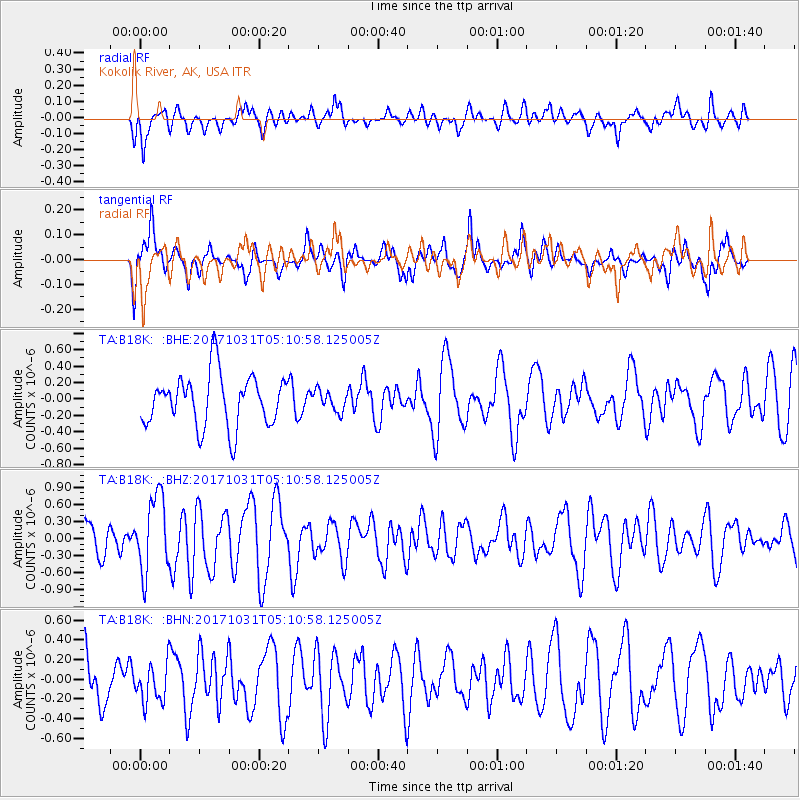
B18K Kokolik River, AK, USA - Earthquake Result Viewer
*The percent match for this event was below the threshold and hence no stack was calculated.
| Earthquake location: |
Tonga Islands |
| Earthquake latitude/longitude: |
-15.5/-173.3 |
| Earthquake time(UTC): |
2017/10/31 (304) 04:58:58 GMT |
| Earthquake Depth: |
35 km |
| Earthquake Magnitude: |
5.8 mb |
| Earthquake Catalog/Contributor: |
NEIC PDE/us |
|
| Network: |
TA USArray Transportable Network (new EarthScope stations) |
| Station: |
B18K Kokolik River, AK, USA |
| Lat/Lon: |
69.36 N/161.80 W |
| Elevation: |
222 m |
|
| Distance: |
85.1 deg |
| Az: |
4.075 deg |
| Baz: |
191.14 deg |
| Ray Param: |
$rayparam |
*The percent match for this event was below the threshold and hence was not used in the summary stack. |
|
| Radial Match: |
52.189667 % |
| Radial Bump: |
400 |
| Transverse Match: |
52.07857 % |
| Transverse Bump: |
357 |
| SOD ConfigId: |
13570011 |
| Insert Time: |
2019-04-29 01:33:22.600 +0000 |
| GWidth: |
2.5 |
| Max Bumps: |
400 |
| Tol: |
0.001 |
|
Signal To Noise
| Channel | StoN | STA | LTA |
| TA:B18K: :BHZ:20171031T05:10:58.125005Z | 1.7939956 | 6.6159754E-7 | 3.6878436E-7 |
| TA:B18K: :BHN:20171031T05:10:58.125005Z | 0.86856633 | 1.9785685E-7 | 2.2779705E-7 |
| TA:B18K: :BHE:20171031T05:10:58.125005Z | 0.39875677 | 1.2534238E-7 | 3.1433294E-7 |
| Arrivals |
| Ps | |
| PpPs | |
| PsPs/PpSs | |


