You are here: Home > Network List > TA - USArray Transportable Network (new EarthScope stations) Stations List
> Station E20K Nigu River, AK, USA > Earthquake Result Viewer
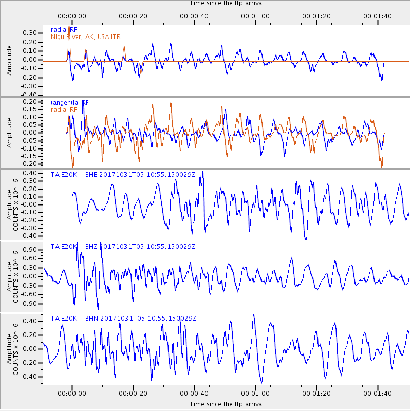
E20K Nigu River, AK, USA - Earthquake Result Viewer
*The percent match for this event was below the threshold and hence no stack was calculated.
| Earthquake location: |
Tonga Islands |
| Earthquake latitude/longitude: |
-15.5/-173.3 |
| Earthquake time(UTC): |
2017/10/31 (304) 04:58:58 GMT |
| Earthquake Depth: |
35 km |
| Earthquake Magnitude: |
5.8 mb |
| Earthquake Catalog/Contributor: |
NEIC PDE/us |
|
| Network: |
TA USArray Transportable Network (new EarthScope stations) |
| Station: |
E20K Nigu River, AK, USA |
| Lat/Lon: |
68.26 N/156.19 W |
| Elevation: |
866 m |
|
| Distance: |
84.5 deg |
| Az: |
6.331 deg |
| Baz: |
196.576 deg |
| Ray Param: |
$rayparam |
*The percent match for this event was below the threshold and hence was not used in the summary stack. |
|
| Radial Match: |
70.08467 % |
| Radial Bump: |
385 |
| Transverse Match: |
42.63551 % |
| Transverse Bump: |
340 |
| SOD ConfigId: |
13570011 |
| Insert Time: |
2019-04-29 01:33:36.869 +0000 |
| GWidth: |
2.5 |
| Max Bumps: |
400 |
| Tol: |
0.001 |
|
Signal To Noise
| Channel | StoN | STA | LTA |
| TA:E20K: :BHZ:20171031T05:10:55.150029Z | 5.47706 | 5.8510307E-7 | 1.06827954E-7 |
| TA:E20K: :BHN:20171031T05:10:55.150029Z | 0.9056661 | 1.33874E-7 | 1.4781827E-7 |
| TA:E20K: :BHE:20171031T05:10:55.150029Z | 1.8568715 | 2.0164882E-7 | 1.08596E-7 |
| Arrivals |
| Ps | |
| PpPs | |
| PsPs/PpSs | |


