You are here: Home > Network List > TA - USArray Transportable Network (new EarthScope stations) Stations List
> Station G31M Satah River, YT, CAN > Earthquake Result Viewer
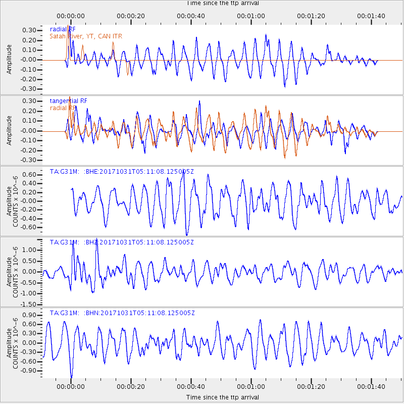
G31M Satah River, YT, CAN - Earthquake Result Viewer
*The percent match for this event was below the threshold and hence no stack was calculated.
| Earthquake location: |
Tonga Islands |
| Earthquake latitude/longitude: |
-15.5/-173.3 |
| Earthquake time(UTC): |
2017/10/31 (304) 04:58:58 GMT |
| Earthquake Depth: |
35 km |
| Earthquake Magnitude: |
5.8 mb |
| Earthquake Catalog/Contributor: |
NEIC PDE/us |
|
| Network: |
TA USArray Transportable Network (new EarthScope stations) |
| Station: |
G31M Satah River, YT, CAN |
| Lat/Lon: |
66.92 N/134.27 W |
| Elevation: |
61 m |
|
| Distance: |
87.1 deg |
| Az: |
14.399 deg |
| Baz: |
217.449 deg |
| Ray Param: |
$rayparam |
*The percent match for this event was below the threshold and hence was not used in the summary stack. |
|
| Radial Match: |
50.612995 % |
| Radial Bump: |
400 |
| Transverse Match: |
50.60954 % |
| Transverse Bump: |
400 |
| SOD ConfigId: |
13570011 |
| Insert Time: |
2019-04-29 01:34:02.045 +0000 |
| GWidth: |
2.5 |
| Max Bumps: |
400 |
| Tol: |
0.001 |
|
Signal To Noise
| Channel | StoN | STA | LTA |
| TA:G31M: :BHZ:20171031T05:11:08.125005Z | 2.5967743 | 5.718648E-7 | 2.2022122E-7 |
| TA:G31M: :BHN:20171031T05:11:08.125005Z | 1.3194308 | 4.907144E-7 | 3.719137E-7 |
| TA:G31M: :BHE:20171031T05:11:08.125005Z | 1.6881084 | 3.8055467E-7 | 2.254326E-7 |
| Arrivals |
| Ps | |
| PpPs | |
| PsPs/PpSs | |


