You are here: Home > Network List > IU - Global Seismograph Network (GSN - IRIS/USGS) Stations List
> Station PMG Port Moresby, New Guinea > Earthquake Result Viewer
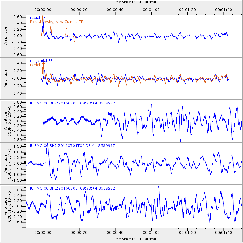
PMG Port Moresby, New Guinea - Earthquake Result Viewer
*The percent match for this event was below the threshold and hence no stack was calculated.
| Earthquake location: |
South Of Kermadec Islands |
| Earthquake latitude/longitude: |
-32.9/-178.4 |
| Earthquake time(UTC): |
2016/03/01 (061) 09:26:45 GMT |
| Earthquake Depth: |
10 km |
| Earthquake Magnitude: |
5.6 MWW, 5.5 MWB, 5.7 MWC |
| Earthquake Catalog/Contributor: |
NEIC PDE/NEIC COMCAT |
|
| Network: |
IU Global Seismograph Network (GSN - IRIS/USGS) |
| Station: |
PMG Port Moresby, New Guinea |
| Lat/Lon: |
9.40 S/147.16 E |
| Elevation: |
90 m |
|
| Distance: |
39.5 deg |
| Az: |
298.554 deg |
| Baz: |
131.533 deg |
| Ray Param: |
$rayparam |
*The percent match for this event was below the threshold and hence was not used in the summary stack. |
|
| Radial Match: |
79.679855 % |
| Radial Bump: |
400 |
| Transverse Match: |
71.62728 % |
| Transverse Bump: |
400 |
| SOD ConfigId: |
1474791 |
| Insert Time: |
2016-04-07 10:04:13.500 +0000 |
| GWidth: |
2.5 |
| Max Bumps: |
400 |
| Tol: |
0.001 |
|
Signal To Noise
| Channel | StoN | STA | LTA |
| IU:PMG:00:BHZ:20160301T09:33:44.868993Z | 5.507755 | 8.0511455E-7 | 1.4617835E-7 |
| IU:PMG:00:BH1:20160301T09:33:44.868993Z | 1.9696583 | 2.3612907E-7 | 1.1988327E-7 |
| IU:PMG:00:BH2:20160301T09:33:44.868993Z | 2.7788742 | 2.444211E-7 | 8.795688E-8 |
| Arrivals |
| Ps | |
| PpPs | |
| PsPs/PpSs | |


