You are here: Home > Network List > TA - USArray Transportable Network (new EarthScope stations) Stations List
> Station KSCO Kaye Shedlock's, Cheyenne Wells, CO, USA > Earthquake Result Viewer
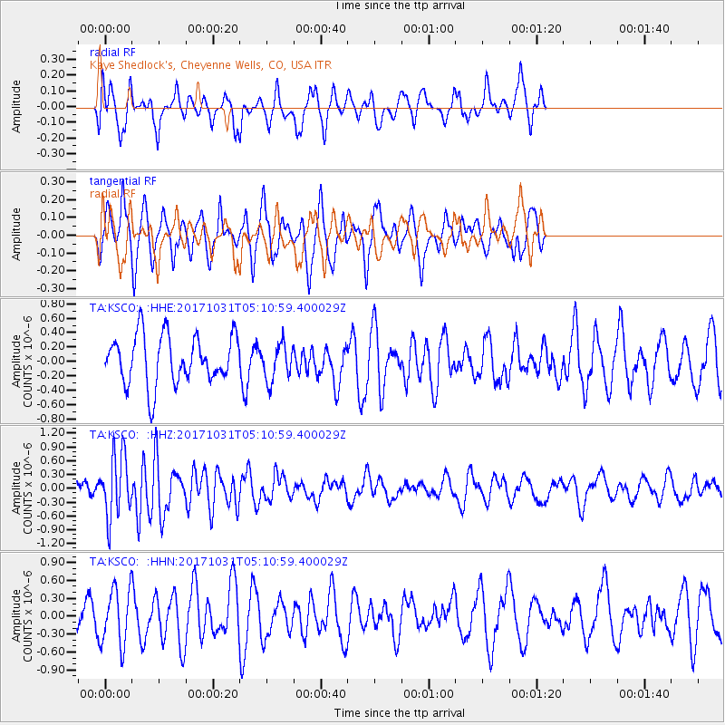
KSCO Kaye Shedlock's, Cheyenne Wells, CO, USA - Earthquake Result Viewer
*The percent match for this event was below the threshold and hence no stack was calculated.
| Earthquake location: |
Tonga Islands |
| Earthquake latitude/longitude: |
-15.5/-173.3 |
| Earthquake time(UTC): |
2017/10/31 (304) 04:58:58 GMT |
| Earthquake Depth: |
35 km |
| Earthquake Magnitude: |
5.8 mb |
| Earthquake Catalog/Contributor: |
NEIC PDE/us |
|
| Network: |
TA USArray Transportable Network (new EarthScope stations) |
| Station: |
KSCO Kaye Shedlock's, Cheyenne Wells, CO, USA |
| Lat/Lon: |
39.01 N/102.63 W |
| Elevation: |
1382 m |
|
| Distance: |
85.3 deg |
| Az: |
47.538 deg |
| Baz: |
245.891 deg |
| Ray Param: |
$rayparam |
*The percent match for this event was below the threshold and hence was not used in the summary stack. |
|
| Radial Match: |
46.925568 % |
| Radial Bump: |
354 |
| Transverse Match: |
50.08714 % |
| Transverse Bump: |
305 |
| SOD ConfigId: |
13570011 |
| Insert Time: |
2019-04-29 01:34:22.545 +0000 |
| GWidth: |
2.5 |
| Max Bumps: |
400 |
| Tol: |
0.001 |
|
Signal To Noise
| Channel | StoN | STA | LTA |
| TA:KSCO: :HHZ:20171031T05:10:59.400029Z | 3.447813 | 6.746422E-7 | 1.956725E-7 |
| TA:KSCO: :HHN:20171031T05:10:59.400029Z | 1.215406 | 4.7264965E-7 | 3.8888214E-7 |
| TA:KSCO: :HHE:20171031T05:10:59.400029Z | 0.7337046 | 2.536958E-7 | 3.4577374E-7 |
| Arrivals |
| Ps | |
| PpPs | |
| PsPs/PpSs | |


