You are here: Home > Network List > TA - USArray Transportable Network (new EarthScope stations) Stations List
> Station L20K Farewell, AK, USA > Earthquake Result Viewer
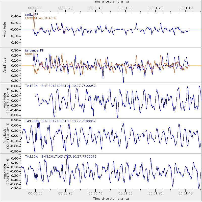
L20K Farewell, AK, USA - Earthquake Result Viewer
*The percent match for this event was below the threshold and hence no stack was calculated.
| Earthquake location: |
Tonga Islands |
| Earthquake latitude/longitude: |
-15.5/-173.3 |
| Earthquake time(UTC): |
2017/10/31 (304) 04:58:58 GMT |
| Earthquake Depth: |
35 km |
| Earthquake Magnitude: |
5.8 mb |
| Earthquake Catalog/Contributor: |
NEIC PDE/us |
|
| Network: |
TA USArray Transportable Network (new EarthScope stations) |
| Station: |
L20K Farewell, AK, USA |
| Lat/Lon: |
62.48 N/153.88 W |
| Elevation: |
673 m |
|
| Distance: |
79.2 deg |
| Az: |
9.054 deg |
| Baz: |
199.061 deg |
| Ray Param: |
$rayparam |
*The percent match for this event was below the threshold and hence was not used in the summary stack. |
|
| Radial Match: |
55.853016 % |
| Radial Bump: |
373 |
| Transverse Match: |
68.973656 % |
| Transverse Bump: |
400 |
| SOD ConfigId: |
13570011 |
| Insert Time: |
2019-04-29 01:34:25.354 +0000 |
| GWidth: |
2.5 |
| Max Bumps: |
400 |
| Tol: |
0.001 |
|
Signal To Noise
| Channel | StoN | STA | LTA |
| TA:L20K: :BHZ:20171031T05:10:27.750005Z | 2.7189245 | 5.646512E-7 | 2.0767447E-7 |
| TA:L20K: :BHN:20171031T05:10:27.750005Z | 0.91772187 | 2.5734835E-7 | 2.8042083E-7 |
| TA:L20K: :BHE:20171031T05:10:27.750005Z | 0.9828873 | 2.6348982E-7 | 2.6807734E-7 |
| Arrivals |
| Ps | |
| PpPs | |
| PsPs/PpSs | |


