You are here: Home > Network List > TA - USArray Transportable Network (new EarthScope stations) Stations List
> Station MSTX Muleshoe, TX, USA > Earthquake Result Viewer
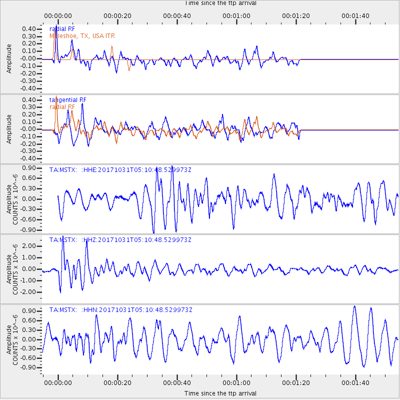
MSTX Muleshoe, TX, USA - Earthquake Result Viewer
*The percent match for this event was below the threshold and hence no stack was calculated.
| Earthquake location: |
Tonga Islands |
| Earthquake latitude/longitude: |
-15.5/-173.3 |
| Earthquake time(UTC): |
2017/10/31 (304) 04:58:58 GMT |
| Earthquake Depth: |
35 km |
| Earthquake Magnitude: |
5.8 mb |
| Earthquake Catalog/Contributor: |
NEIC PDE/us |
|
| Network: |
TA USArray Transportable Network (new EarthScope stations) |
| Station: |
MSTX Muleshoe, TX, USA |
| Lat/Lon: |
33.97 N/102.77 W |
| Elevation: |
1167 m |
|
| Distance: |
83.2 deg |
| Az: |
52.113 deg |
| Baz: |
246.264 deg |
| Ray Param: |
$rayparam |
*The percent match for this event was below the threshold and hence was not used in the summary stack. |
|
| Radial Match: |
61.160206 % |
| Radial Bump: |
344 |
| Transverse Match: |
55.952568 % |
| Transverse Bump: |
400 |
| SOD ConfigId: |
13570011 |
| Insert Time: |
2019-04-29 01:34:33.283 +0000 |
| GWidth: |
2.5 |
| Max Bumps: |
400 |
| Tol: |
0.001 |
|
Signal To Noise
| Channel | StoN | STA | LTA |
| TA:MSTX: :HHZ:20171031T05:10:48.529973Z | 5.9595504 | 1.157583E-6 | 1.9423997E-7 |
| TA:MSTX: :HHN:20171031T05:10:48.529973Z | 0.69150645 | 2.010889E-7 | 2.907983E-7 |
| TA:MSTX: :HHE:20171031T05:10:48.529973Z | 2.9899352 | 5.3104304E-7 | 1.7761022E-7 |
| Arrivals |
| Ps | |
| PpPs | |
| PsPs/PpSs | |


