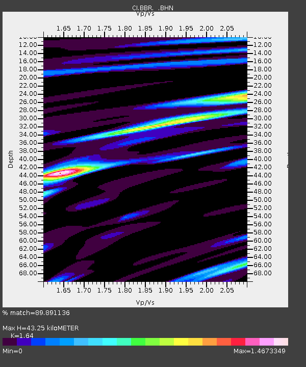
BBR Big Bear Solar Observatory - Earthquake Result Viewer

Earthquake location: Kuril Islands
Earthquake latitude/longitude: 46.5/153.2
Earthquake time(UTC): 2006/10/01 (274) 09:06:02 GMT
Earthquake Depth: 19 km
Earthquake Magnitude: 6.1 MB, 6.4 MS, 6.6 MW, 6.5 MW
Earthquake Catalog/Contributor: WHDF/NEIC
Network: CI Caltech Regional Seismic Network
Station: BBR Big Bear Solar Observatory
Lat/Lon: 34.26 N/116.92 W
Elevation: 2069 m
Distance: 66.0 deg
Az: 65.032 deg
Baz: 310.842 deg
Ray Param: 0.057878632
Estimated Moho Depth: 43.25 km
Estimated Crust Vp/Vs: 1.64
Assumed Crust Vp: 6.276 km/s
Estimated Crust Vs: 3.827 km/s
Estimated Crust Poisson's Ratio: 0.20
Radial Match: 89.891136 %
Radial Bump: 400
Transverse Match: 84.81328 %
Transverse Bump: 400
SOD ConfigId: 2665
Insert Time: 2010-02-26 01:33:54.460 +0000
GWidth: 2.5
Max Bumps: 400
Tol: 0.001

Signal To Noise

ChannelStoNSTALTA
CI:BBR: :BHN:20061001T09:16:16.379021Z3.2700212.6608052E-78.136966E-8
CI:BBR: :BHE:20061001T09:16:16.379021Z2.91097972.9987365E-71.03014685E-7
CI:BBR: :BHZ:20061001T09:16:16.379021Z6.8067457.627259E-71.1205443E-7
Arrivals
Ps4.6 SECOND
PpPs17 SECOND
PsPs/PpSs22 SECOND