You are here: Home > Network List > TA - USArray Transportable Network (new EarthScope stations) Stations List
> Station N16A Rees Ranch, Coalville, UT, USA > Earthquake Result Viewer
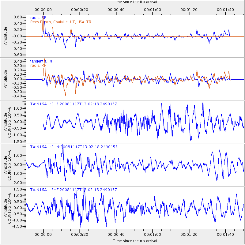
N16A Rees Ranch, Coalville, UT, USA - Earthquake Result Viewer
*The percent match for this event was below the threshold and hence no stack was calculated.
| Earthquake location: |
Arctic Ocean |
| Earthquake latitude/longitude: |
79.6/-116.1 |
| Earthquake time(UTC): |
2008/11/17 (322) 12:55:22 GMT |
| Earthquake Depth: |
7.0 km |
| Earthquake Magnitude: |
5.7 MW, 5.2 MS, 5.4 MB, 5.7 MW |
| Earthquake Catalog/Contributor: |
WHDF/NEIC |
|
| Network: |
TA USArray Transportable Network (new EarthScope stations) |
| Station: |
N16A Rees Ranch, Coalville, UT, USA |
| Lat/Lon: |
40.89 N/111.44 W |
| Elevation: |
2028 m |
|
| Distance: |
38.9 deg |
| Az: |
174.423 deg |
| Baz: |
358.672 deg |
| Ray Param: |
$rayparam |
*The percent match for this event was below the threshold and hence was not used in the summary stack. |
|
| Radial Match: |
72.59419 % |
| Radial Bump: |
400 |
| Transverse Match: |
55.67627 % |
| Transverse Bump: |
400 |
| SOD ConfigId: |
2658 |
| Insert Time: |
2010-03-06 05:40:43.528 +0000 |
| GWidth: |
2.5 |
| Max Bumps: |
400 |
| Tol: |
0.001 |
|
Signal To Noise
| Channel | StoN | STA | LTA |
| TA:N16A: :BHN:20081117T13:02:18.249015Z | 2.401539 | 5.4001436E-7 | 2.2486176E-7 |
| TA:N16A: :BHE:20081117T13:02:18.249015Z | 1.1269089 | 3.1379338E-7 | 2.7845496E-7 |
| TA:N16A: :BHZ:20081117T13:02:18.249015Z | 1.3301725 | 4.1229185E-7 | 3.0995366E-7 |
| Arrivals |
| Ps | |
| PpPs | |
| PsPs/PpSs | |


