You are here: Home > Network List > TA - USArray Transportable Network (new EarthScope stations) Stations List
> Station WHTX Lake Whitney, Meridian, TX, USA > Earthquake Result Viewer
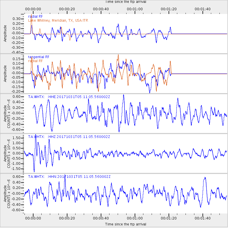
WHTX Lake Whitney, Meridian, TX, USA - Earthquake Result Viewer
*The percent match for this event was below the threshold and hence no stack was calculated.
| Earthquake location: |
Tonga Islands |
| Earthquake latitude/longitude: |
-15.5/-173.3 |
| Earthquake time(UTC): |
2017/10/31 (304) 04:58:58 GMT |
| Earthquake Depth: |
35 km |
| Earthquake Magnitude: |
5.8 mb |
| Earthquake Catalog/Contributor: |
NEIC PDE/us |
|
| Network: |
TA USArray Transportable Network (new EarthScope stations) |
| Station: |
WHTX Lake Whitney, Meridian, TX, USA |
| Lat/Lon: |
31.99 N/97.46 W |
| Elevation: |
190 m |
|
| Distance: |
86.6 deg |
| Az: |
55.636 deg |
| Baz: |
249.461 deg |
| Ray Param: |
$rayparam |
*The percent match for this event was below the threshold and hence was not used in the summary stack. |
|
| Radial Match: |
58.228928 % |
| Radial Bump: |
400 |
| Transverse Match: |
36.63247 % |
| Transverse Bump: |
400 |
| SOD ConfigId: |
13570011 |
| Insert Time: |
2019-04-29 01:35:01.458 +0000 |
| GWidth: |
2.5 |
| Max Bumps: |
400 |
| Tol: |
0.001 |
|
Signal To Noise
| Channel | StoN | STA | LTA |
| TA:WHTX: :HHZ:20171031T05:11:05.560002Z | 5.702036 | 8.9989703E-7 | 1.5782031E-7 |
| TA:WHTX: :HHN:20171031T05:11:05.560002Z | 0.93609077 | 1.5430066E-7 | 1.6483516E-7 |
| TA:WHTX: :HHE:20171031T05:11:05.560002Z | 0.8038515 | 2.1189194E-7 | 2.635959E-7 |
| Arrivals |
| Ps | |
| PpPs | |
| PsPs/PpSs | |


