You are here: Home > Network List > UW - Pacific Northwest Regional Seismic Network Stations List
> Station FISH Seaside, OR, USA > Earthquake Result Viewer
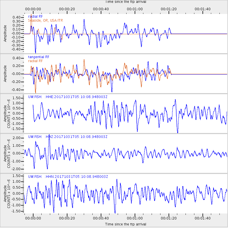
FISH Seaside, OR, USA - Earthquake Result Viewer
*The percent match for this event was below the threshold and hence no stack was calculated.
| Earthquake location: |
Tonga Islands |
| Earthquake latitude/longitude: |
-15.5/-173.3 |
| Earthquake time(UTC): |
2017/10/31 (304) 04:58:58 GMT |
| Earthquake Depth: |
35 km |
| Earthquake Magnitude: |
5.8 mb |
| Earthquake Catalog/Contributor: |
NEIC PDE/us |
|
| Network: |
UW Pacific Northwest Regional Seismic Network |
| Station: |
FISH Seaside, OR, USA |
| Lat/Lon: |
45.93 N/123.56 W |
| Elevation: |
325 m |
|
| Distance: |
75.9 deg |
| Az: |
33.325 deg |
| Baz: |
229.357 deg |
| Ray Param: |
$rayparam |
*The percent match for this event was below the threshold and hence was not used in the summary stack. |
|
| Radial Match: |
49.471554 % |
| Radial Bump: |
400 |
| Transverse Match: |
53.06035 % |
| Transverse Bump: |
400 |
| SOD ConfigId: |
13570011 |
| Insert Time: |
2019-04-29 01:35:46.282 +0000 |
| GWidth: |
2.5 |
| Max Bumps: |
400 |
| Tol: |
0.001 |
|
Signal To Noise
| Channel | StoN | STA | LTA |
| UW:FISH: :HHZ:20171031T05:10:08.948003Z | 2.8610604 | 9.106298E-7 | 3.18284E-7 |
| UW:FISH: :HHN:20171031T05:10:08.948003Z | 1.0802402 | 4.5656395E-7 | 4.2265037E-7 |
| UW:FISH: :HHE:20171031T05:10:08.948003Z | 1.0993781 | 4.3026435E-7 | 3.9137066E-7 |
| Arrivals |
| Ps | |
| PpPs | |
| PsPs/PpSs | |


