You are here: Home > Network List > UW - Pacific Northwest Regional Seismic Network Stations List
> Station MRBL Marblemount, WA, USA > Earthquake Result Viewer
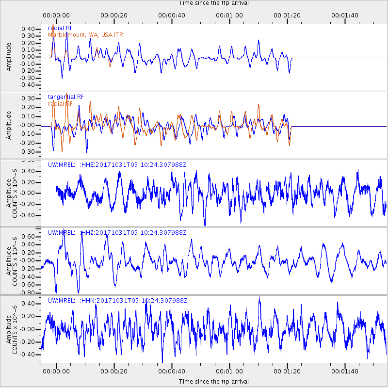
MRBL Marblemount, WA, USA - Earthquake Result Viewer
*The percent match for this event was below the threshold and hence no stack was calculated.
| Earthquake location: |
Tonga Islands |
| Earthquake latitude/longitude: |
-15.5/-173.3 |
| Earthquake time(UTC): |
2017/10/31 (304) 04:58:58 GMT |
| Earthquake Depth: |
35 km |
| Earthquake Magnitude: |
5.8 mb |
| Earthquake Catalog/Contributor: |
NEIC PDE/us |
|
| Network: |
UW Pacific Northwest Regional Seismic Network |
| Station: |
MRBL Marblemount, WA, USA |
| Lat/Lon: |
48.52 N/121.48 W |
| Elevation: |
75 m |
|
| Distance: |
78.6 deg |
| Az: |
32.224 deg |
| Baz: |
230.632 deg |
| Ray Param: |
$rayparam |
*The percent match for this event was below the threshold and hence was not used in the summary stack. |
|
| Radial Match: |
68.8189 % |
| Radial Bump: |
400 |
| Transverse Match: |
47.929173 % |
| Transverse Bump: |
400 |
| SOD ConfigId: |
13570011 |
| Insert Time: |
2019-04-29 01:35:55.595 +0000 |
| GWidth: |
2.5 |
| Max Bumps: |
400 |
| Tol: |
0.001 |
|
Signal To Noise
| Channel | StoN | STA | LTA |
| UW:MRBL: :HHZ:20171031T05:10:24.307988Z | 3.734563 | 3.9739E-7 | 1.064087E-7 |
| UW:MRBL: :HHN:20171031T05:10:24.307988Z | 0.60481924 | 8.44144E-8 | 1.3956964E-7 |
| UW:MRBL: :HHE:20171031T05:10:24.307988Z | 0.77110416 | 1.2476893E-7 | 1.6180556E-7 |
| Arrivals |
| Ps | |
| PpPs | |
| PsPs/PpSs | |


