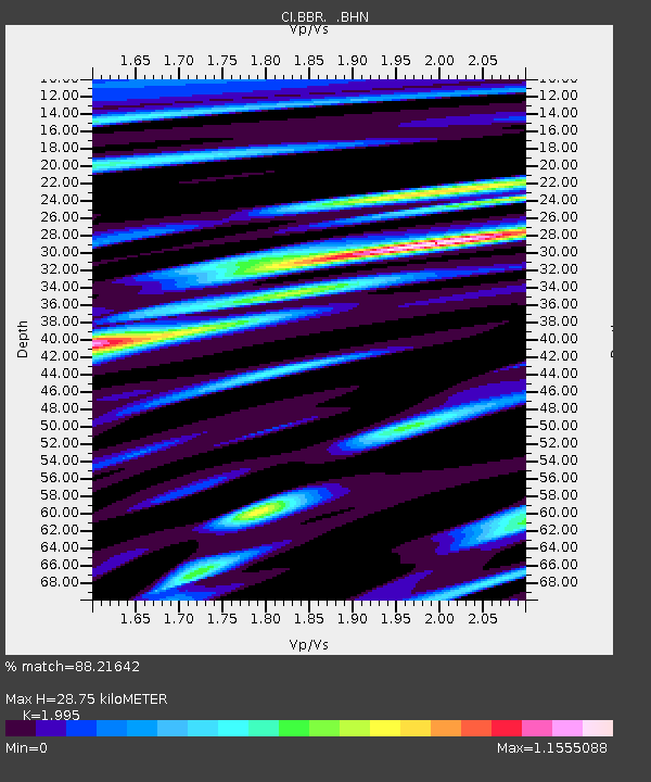
BBR Big Bear Solar Observatory - Earthquake Result Viewer

Earthquake location: Samoa Islands Region
Earthquake latitude/longitude: -16.6/-172.0
Earthquake time(UTC): 2006/09/28 (271) 06:22:09 GMT
Earthquake Depth: 28 km
Earthquake Magnitude: 6.5 MB, 6.6 MS, 6.9 MW, 6.7 MW
Earthquake Catalog/Contributor: WHDF/NEIC
Network: CI Caltech Regional Seismic Network
Station: BBR Big Bear Solar Observatory
Lat/Lon: 34.26 N/116.92 W
Elevation: 2069 m
Distance: 72.8 deg
Az: 45.321 deg
Baz: 235.41 deg
Ray Param: 0.053366005
Estimated Moho Depth: 28.75 km
Estimated Crust Vp/Vs: 2.00
Assumed Crust Vp: 6.276 km/s
Estimated Crust Vs: 3.146 km/s
Estimated Crust Poisson's Ratio: 0.33
Radial Match: 88.21642 %
Radial Bump: 400
Transverse Match: 87.685875 %
Transverse Bump: 400
SOD ConfigId: 2665
Insert Time: 2010-02-26 01:33:57.987 +0000
GWidth: 2.5
Max Bumps: 400
Tol: 0.001

Signal To Noise

ChannelStoNSTALTA
CI:BBR: :BHN:20060928T06:33:04.703022Z4.4394585.0889673E-71.1463038E-7
CI:BBR: :BHE:20060928T06:33:04.703022Z11.0549181.197271E-61.0830212E-7
CI:BBR: :BHZ:20060928T06:33:04.703022Z31.0303693.1118761E-61.0028486E-7
Arrivals
Ps4.7 SECOND
PpPs13 SECOND
PsPs/PpSs18 SECOND