You are here: Home > Network List > TA - USArray Transportable Network (new EarthScope stations) Stations List
> Station N16A Rees Ranch, Coalville, UT, USA > Earthquake Result Viewer
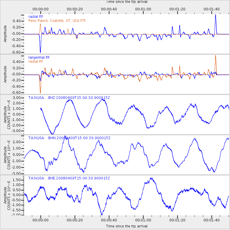
N16A Rees Ranch, Coalville, UT, USA - Earthquake Result Viewer
*The percent match for this event was below the threshold and hence no stack was calculated.
| Earthquake location: |
Vanuatu Islands |
| Earthquake latitude/longitude: |
-20.0/168.9 |
| Earthquake time(UTC): |
2008/04/09 (100) 14:47:50 GMT |
| Earthquake Depth: |
35 km |
| Earthquake Magnitude: |
5.9 MB, 6.2 MS, 6.3 MW |
| Earthquake Catalog/Contributor: |
WHDF/NEIC |
|
| Network: |
TA USArray Transportable Network (new EarthScope stations) |
| Station: |
N16A Rees Ranch, Coalville, UT, USA |
| Lat/Lon: |
40.89 N/111.44 W |
| Elevation: |
2028 m |
|
| Distance: |
95.4 deg |
| Az: |
48.525 deg |
| Baz: |
248.338 deg |
| Ray Param: |
$rayparam |
*The percent match for this event was below the threshold and hence was not used in the summary stack. |
|
| Radial Match: |
72.98159 % |
| Radial Bump: |
382 |
| Transverse Match: |
39.775177 % |
| Transverse Bump: |
400 |
| SOD ConfigId: |
2504 |
| Insert Time: |
2010-03-06 05:41:34.739 +0000 |
| GWidth: |
2.5 |
| Max Bumps: |
400 |
| Tol: |
0.001 |
|
Signal To Noise
| Channel | StoN | STA | LTA |
| TA:N16A: :BHN:20080409T15:00:39.900015Z | 1.3742287 | 1.5886593E-6 | 1.1560371E-6 |
| TA:N16A: :BHE:20080409T15:00:39.900015Z | 0.75880224 | 7.4092276E-7 | 9.764371E-7 |
| TA:N16A: :BHZ:20080409T15:00:39.900015Z | 0.9015745 | 1.7194131E-6 | 1.9071226E-6 |
| Arrivals |
| Ps | |
| PpPs | |
| PsPs/PpSs | |


