You are here: Home > Network List > TA - USArray Transportable Network (new EarthScope stations) Stations List
> Station G23K Bananza Creek, AK, USA > Earthquake Result Viewer
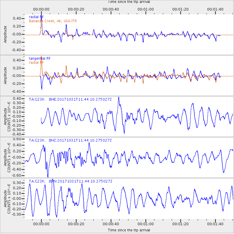
G23K Bananza Creek, AK, USA - Earthquake Result Viewer
*The percent match for this event was below the threshold and hence no stack was calculated.
| Earthquake location: |
Seram, Indonesia |
| Earthquake latitude/longitude: |
-3.8/127.7 |
| Earthquake time(UTC): |
2017/10/31 (304) 11:31:42 GMT |
| Earthquake Depth: |
27 km |
| Earthquake Magnitude: |
5.9 Mww |
| Earthquake Catalog/Contributor: |
NEIC PDE/us |
|
| Network: |
TA USArray Transportable Network (new EarthScope stations) |
| Station: |
G23K Bananza Creek, AK, USA |
| Lat/Lon: |
66.71 N/150.02 W |
| Elevation: |
746 m |
|
| Distance: |
90.4 deg |
| Az: |
23.204 deg |
| Baz: |
261.399 deg |
| Ray Param: |
$rayparam |
*The percent match for this event was below the threshold and hence was not used in the summary stack. |
|
| Radial Match: |
68.491905 % |
| Radial Bump: |
366 |
| Transverse Match: |
62.282448 % |
| Transverse Bump: |
400 |
| SOD ConfigId: |
13570011 |
| Insert Time: |
2019-04-29 01:39:36.084 +0000 |
| GWidth: |
2.5 |
| Max Bumps: |
400 |
| Tol: |
0.001 |
|
Signal To Noise
| Channel | StoN | STA | LTA |
| TA:G23K: :BHZ:20171031T11:44:10.275027Z | 1.7956377 | 3.1542652E-7 | 1.7566268E-7 |
| TA:G23K: :BHN:20171031T11:44:10.275027Z | 1.209776 | 1.9402549E-7 | 1.6038133E-7 |
| TA:G23K: :BHE:20171031T11:44:10.275027Z | 1.140643 | 1.18913206E-7 | 1.0425102E-7 |
| Arrivals |
| Ps | |
| PpPs | |
| PsPs/PpSs | |


