You are here: Home > Network List > TA - USArray Transportable Network (new EarthScope stations) Stations List
> Station N16A Rees Ranch, Coalville, UT, USA > Earthquake Result Viewer
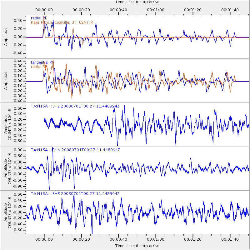
N16A Rees Ranch, Coalville, UT, USA - Earthquake Result Viewer
*The percent match for this event was below the threshold and hence no stack was calculated.
| Earthquake location: |
Central Peru |
| Earthquake latitude/longitude: |
-10.4/-75.5 |
| Earthquake time(UTC): |
2008/07/01 (183) 00:17:33 GMT |
| Earthquake Depth: |
33 km |
| Earthquake Magnitude: |
5.5 MW, 5.0 MS, 5.4 MB, 5.3 ML |
| Earthquake Catalog/Contributor: |
WHDF/NEIC |
|
| Network: |
TA USArray Transportable Network (new EarthScope stations) |
| Station: |
N16A Rees Ranch, Coalville, UT, USA |
| Lat/Lon: |
40.89 N/111.44 W |
| Elevation: |
2028 m |
|
| Distance: |
60.8 deg |
| Az: |
329.371 deg |
| Baz: |
138.613 deg |
| Ray Param: |
$rayparam |
*The percent match for this event was below the threshold and hence was not used in the summary stack. |
|
| Radial Match: |
66.03541 % |
| Radial Bump: |
400 |
| Transverse Match: |
51.257687 % |
| Transverse Bump: |
394 |
| SOD ConfigId: |
2504 |
| Insert Time: |
2010-03-06 05:42:23.120 +0000 |
| GWidth: |
2.5 |
| Max Bumps: |
400 |
| Tol: |
0.001 |
|
Signal To Noise
| Channel | StoN | STA | LTA |
| TA:N16A: :BHN:20080701T00:27:11.448994Z | 8.027126 | 4.6354597E-7 | 5.7747435E-8 |
| TA:N16A: :BHE:20080701T00:27:11.448994Z | 1.0812835 | 1.3928813E-7 | 1.288174E-7 |
| TA:N16A: :BHZ:20080701T00:27:11.448994Z | 1.2002543 | 1.4638616E-7 | 1.2196261E-7 |
| Arrivals |
| Ps | |
| PpPs | |
| PsPs/PpSs | |


