You are here: Home > Network List > TA - USArray Transportable Network (new EarthScope stations) Stations List
> Station C16K Lisburne Hills, AK, USA > Earthquake Result Viewer
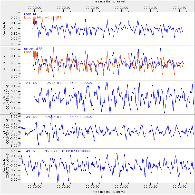
C16K Lisburne Hills, AK, USA - Earthquake Result Viewer
*The percent match for this event was below the threshold and hence no stack was calculated.
| Earthquake location: |
Seram, Indonesia |
| Earthquake latitude/longitude: |
-3.8/127.7 |
| Earthquake time(UTC): |
2017/10/31 (304) 11:34:44 GMT |
| Earthquake Depth: |
48 km |
| Earthquake Magnitude: |
5.7 mb |
| Earthquake Catalog/Contributor: |
NEIC PDE/us |
|
| Network: |
TA USArray Transportable Network (new EarthScope stations) |
| Station: |
C16K Lisburne Hills, AK, USA |
| Lat/Lon: |
68.27 N/165.34 W |
| Elevation: |
102 m |
|
| Distance: |
85.2 deg |
| Az: |
20.115 deg |
| Baz: |
247.172 deg |
| Ray Param: |
$rayparam |
*The percent match for this event was below the threshold and hence was not used in the summary stack. |
|
| Radial Match: |
65.15023 % |
| Radial Bump: |
400 |
| Transverse Match: |
64.704025 % |
| Transverse Bump: |
400 |
| SOD ConfigId: |
13570011 |
| Insert Time: |
2019-04-29 01:42:28.922 +0000 |
| GWidth: |
2.5 |
| Max Bumps: |
400 |
| Tol: |
0.001 |
|
Signal To Noise
| Channel | StoN | STA | LTA |
| TA:C16K: :BHZ:20171031T11:46:44.400002Z | 1.7703986 | 5.02838E-7 | 2.840253E-7 |
| TA:C16K: :BHN:20171031T11:46:44.400002Z | 0.83042216 | 2.0138097E-7 | 2.425043E-7 |
| TA:C16K: :BHE:20171031T11:46:44.400002Z | 1.3766412 | 2.2804976E-7 | 1.6565664E-7 |
| Arrivals |
| Ps | |
| PpPs | |
| PsPs/PpSs | |


