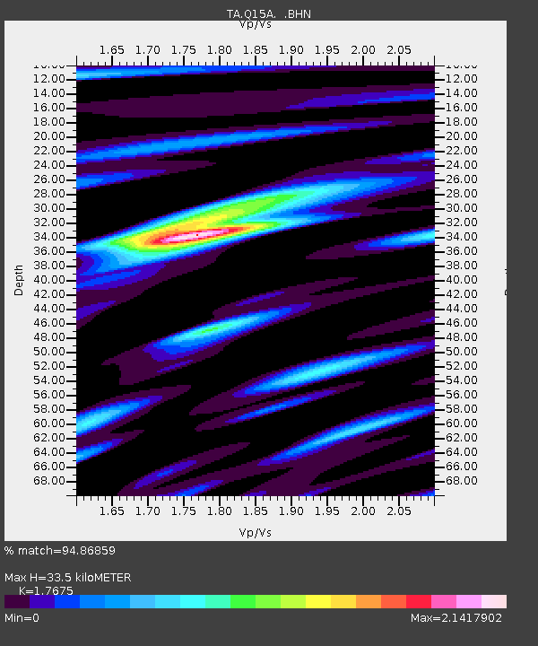
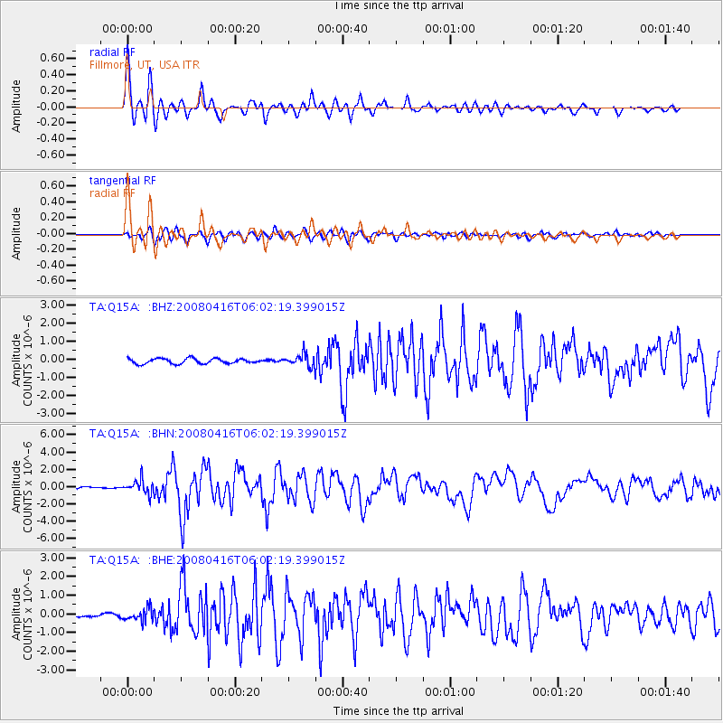
Q15A Fillmore, UT, USA - Earthquake Result Viewer

Earthquake location: Andreanof Islands, Aleutian Is.
Earthquake latitude/longitude: 51.9/-179.2
Earthquake time(UTC): 2008/04/16 (107) 05:54:19 GMT
Earthquake Depth: 13 km
Earthquake Magnitude: 6.1 MB, 6.5 MS, 6.6 MW, 6.6 MW
Earthquake Catalog/Contributor: WHDF/NEIC
Network: TA USArray Transportable Network (new EarthScope stations)
Station: Q15A Fillmore, UT, USA
Lat/Lon: 39.00 N/112.38 W
Elevation: 1477 m
Distance: 47.0 deg
Az: 78.36 deg
Baz: 308.814 deg
Ray Param: 0.070284255
Estimated Moho Depth: 33.5 km
Estimated Crust Vp/Vs: 1.77
Assumed Crust Vp: 6.276 km/s
Estimated Crust Vs: 3.551 km/s
Estimated Crust Poisson's Ratio: 0.26
Radial Match: 94.86859 %
Radial Bump: 400
Transverse Match: 86.41442 %
Transverse Bump: 400
SOD ConfigId: 2504
Insert Time: 2010-03-06 05:42:33.254 +0000
GWidth: 2.5
Max Bumps: 400
Tol: 0.001

Signal To Noise

ChannelStoNSTALTA
TA:Q15A: :BHN:20080416T06:02:19.399015Z7.11981537.927003E-71.113372E-7
TA:Q15A: :BHE:20080416T06:02:19.399015Z3.57875973.333216E-79.313886E-8
TA:Q15A: :BHZ:20080416T06:02:19.399015Z2.43669373.4341053E-71.4093298E-7
Arrivals
Ps4.3 SECOND
PpPs14 SECOND
PsPs/PpSs18 SECOND