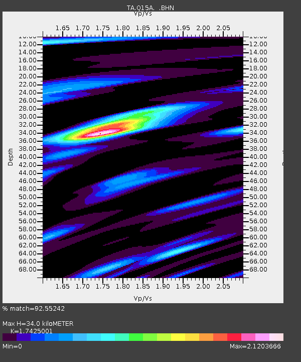
Q15A Fillmore, UT, USA - Earthquake Result Viewer
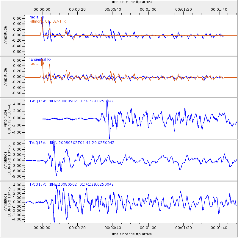
Earthquake location: Andreanof Islands, Aleutian Is.
Earthquake latitude/longitude: 51.9/-177.5
Earthquake time(UTC): 2008/05/02 (123) 01:33:37 GMT
Earthquake Depth: 14 km
Earthquake Magnitude: 6.3 MB, 6.8 MS, 6.6 MW, 6.6 MW
Earthquake Catalog/Contributor: WHDF/NEIC
Network: TA USArray Transportable Network (new EarthScope stations)
Station: Q15A Fillmore, UT, USA
Lat/Lon: 39.00 N/112.38 W
Elevation: 1477 m
Distance: 46.0 deg
Az: 79.446 deg
Baz: 308.525 deg
Ray Param: 0.07091133
Estimated Moho Depth: 34.0 km
Estimated Crust Vp/Vs: 1.74
Assumed Crust Vp: 6.276 km/s
Estimated Crust Vs: 3.602 km/s
Estimated Crust Poisson's Ratio: 0.25
Radial Match: 92.55242 %
Radial Bump: 400
Transverse Match: 80.1532 %
Transverse Bump: 400
SOD ConfigId: 2504
Insert Time: 2010-03-06 05:42:39.312 +0000
GWidth: 2.5
Max Bumps: 400
Tol: 0.001

Signal To Noise

ChannelStoNSTALTA
TA:Q15A: :BHN:20080502T01:41:29.025004Z11.6682851.335446E-61.1445092E-7
TA:Q15A: :BHE:20080502T01:41:29.025004Z4.725525.741622E-71.2150244E-7
TA:Q15A: :BHZ:20080502T01:41:29.025004Z4.8457056.562166E-71.3542233E-7
Arrivals
Ps4.3 SECOND
PpPs14 SECOND
PsPs/PpSs18 SECOND