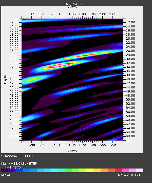
Q15A Fillmore, UT, USA - Earthquake Result Viewer
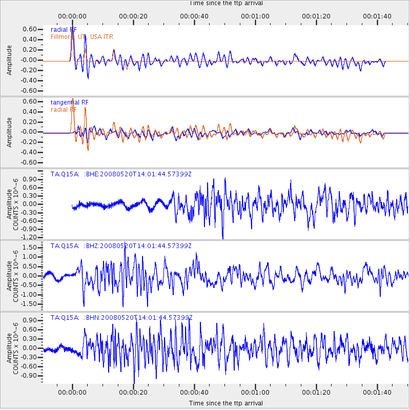
Earthquake location: Rat Islands, Aleutian Islands
Earthquake latitude/longitude: 51.2/178.8
Earthquake time(UTC): 2008/05/20 (141) 13:53:35 GMT
Earthquake Depth: 27 km
Earthquake Magnitude: 5.8 MB, 6.0 MS, 6.3 MW, 6.3 MW
Earthquake Catalog/Contributor: WHDF/NEIC
Network: TA USArray Transportable Network (new EarthScope stations)
Station: Q15A Fillmore, UT, USA
Lat/Lon: 39.00 N/112.38 W
Elevation: 1477 m
Distance: 48.4 deg
Az: 76.361 deg
Baz: 308.251 deg
Ray Param: 0.06933542
Estimated Moho Depth: 33.0 km
Estimated Crust Vp/Vs: 1.79
Assumed Crust Vp: 6.276 km/s
Estimated Crust Vs: 3.511 km/s
Estimated Crust Poisson's Ratio: 0.27
Radial Match: 83.31143 %
Radial Bump: 400
Transverse Match: 76.75088 %
Transverse Bump: 400
SOD ConfigId: 2504
Insert Time: 2010-03-06 05:42:46.250 +0000
GWidth: 2.5
Max Bumps: 400
Tol: 0.001

Signal To Noise

ChannelStoNSTALTA
TA:Q15A: :BHZ:20080520T14:01:44.57399Z5.00630245.0551756E-71.0097624E-7
TA:Q15A: :BHN:20080520T14:01:44.57399Z3.26775382.4308466E-77.438891E-8
TA:Q15A: :BHE:20080520T14:01:44.57399Z2.86886362.4919063E-78.68604E-8
Arrivals
Ps4.4 SECOND
PpPs14 SECOND
PsPs/PpSs18 SECOND