You are here: Home > Network List > TA - USArray Transportable Network (new EarthScope stations) Stations List
> Station Q15A Fillmore, UT, USA > Earthquake Result Viewer
Q15A Fillmore, UT, USA - Earthquake Result Viewer

| Earthquake location: |
Iceland |
| Earthquake latitude/longitude: |
64.0/-21.0 |
| Earthquake time(UTC): |
2008/05/29 (150) 15:46:00 GMT |
| Earthquake Depth: |
10 km |
| Earthquake Magnitude: |
6.0 MB, 6.2 MS, 6.3 MW, 6.2 MW |
| Earthquake Catalog/Contributor: |
WHDF/NEIC |
|
| Network: |
TA USArray Transportable Network (new EarthScope stations) |
| Station: |
Q15A Fillmore, UT, USA |
| Lat/Lon: |
39.00 N/112.38 W |
| Elevation: |
1477 m |
|
| Distance: |
56.3 deg |
| Az: |
290.606 deg |
| Baz: |
31.963 deg |
| Ray Param: |
0.06421292 |
| Estimated Moho Depth: |
26.5 km |
| Estimated Crust Vp/Vs: |
1.98 |
| Assumed Crust Vp: |
6.276 km/s |
| Estimated Crust Vs: |
3.17 km/s |
| Estimated Crust Poisson's Ratio: |
0.33 |
|
| Radial Match: |
92.05446 % |
| Radial Bump: |
310 |
| Transverse Match: |
84.602554 % |
| Transverse Bump: |
400 |
| SOD ConfigId: |
2504 |
| Insert Time: |
2010-03-06 05:42:48.741 +0000 |
| GWidth: |
2.5 |
| Max Bumps: |
400 |
| Tol: |
0.001 |
|
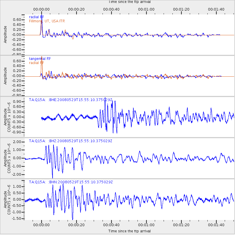
Signal To Noise
| Channel | StoN | STA | LTA |
| TA:Q15A: :BHZ:20080529T15:55:10.375029Z | 8.872907 | 6.510294E-7 | 7.3372725E-8 |
| TA:Q15A: :BHN:20080529T15:55:10.375029Z | 3.730714 | 2.7455832E-7 | 7.3594045E-8 |
| TA:Q15A: :BHE:20080529T15:55:10.375029Z | 2.767992 | 2.601362E-7 | 9.398012E-8 |
| Arrivals |
| Ps | 4.3 SECOND |
| PpPs | 12 SECOND |
| PsPs/PpSs | 16 SECOND |


