You are here: Home > Network List > TA - USArray Transportable Network (new EarthScope stations) Stations List
> Station Q15A Fillmore, UT, USA > Earthquake Result Viewer
Q15A Fillmore, UT, USA - Earthquake Result Viewer

| Earthquake location: |
Hokkaido, Japan Region |
| Earthquake latitude/longitude: |
41.5/139.0 |
| Earthquake time(UTC): |
2008/06/04 (156) 17:03:07 GMT |
| Earthquake Depth: |
213 km |
| Earthquake Magnitude: |
5.5 MB, 5.7 MW, 5.7 MW |
| Earthquake Catalog/Contributor: |
WHDF/NEIC |
|
| Network: |
TA USArray Transportable Network (new EarthScope stations) |
| Station: |
Q15A Fillmore, UT, USA |
| Lat/Lon: |
39.00 N/112.38 W |
| Elevation: |
1477 m |
|
| Distance: |
76.8 deg |
| Az: |
49.337 deg |
| Baz: |
313.041 deg |
| Ray Param: |
0.05017322 |
| Estimated Moho Depth: |
33.75 km |
| Estimated Crust Vp/Vs: |
1.77 |
| Assumed Crust Vp: |
6.276 km/s |
| Estimated Crust Vs: |
3.551 km/s |
| Estimated Crust Poisson's Ratio: |
0.26 |
|
| Radial Match: |
84.16638 % |
| Radial Bump: |
400 |
| Transverse Match: |
67.87548 % |
| Transverse Bump: |
400 |
| SOD ConfigId: |
2504 |
| Insert Time: |
2010-03-06 05:42:52.209 +0000 |
| GWidth: |
2.5 |
| Max Bumps: |
400 |
| Tol: |
0.001 |
|
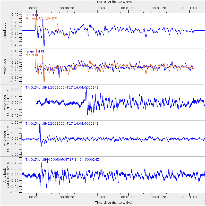
Signal To Noise
| Channel | StoN | STA | LTA |
| TA:Q15A: :BHZ:20080604T17:14:04.600024Z | 7.3864617 | 4.8620706E-7 | 6.582408E-8 |
| TA:Q15A: :BHN:20080604T17:14:04.600024Z | 3.447602 | 1.4895679E-7 | 4.320591E-8 |
| TA:Q15A: :BHE:20080604T17:14:04.600024Z | 4.075736 | 1.9152729E-7 | 4.699207E-8 |
| Arrivals |
| Ps | 4.2 SECOND |
| PpPs | 14 SECOND |
| PsPs/PpSs | 19 SECOND |


