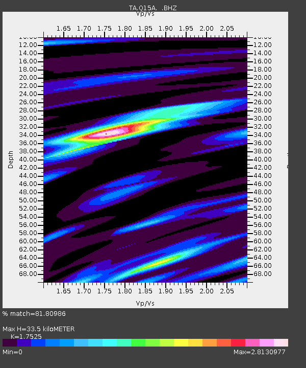
Q15A Fillmore, UT, USA - Earthquake Result Viewer

Earthquake location: Andreanof Islands, Aleutian Is.
Earthquake latitude/longitude: 52.2/-175.7
Earthquake time(UTC): 2008/08/07 (220) 18:30:03 GMT
Earthquake Depth: 12 km
Earthquake Magnitude: 5.6 MB, 5.5 MS, 5.8 MW, 5.8 MW
Earthquake Catalog/Contributor: WHDF/NEIC
Network: TA USArray Transportable Network (new EarthScope stations)
Station: Q15A Fillmore, UT, USA
Lat/Lon: 39.00 N/112.38 W
Elevation: 1477 m
Distance: 44.8 deg
Az: 81.045 deg
Baz: 308.701 deg
Ray Param: 0.07169331
Estimated Moho Depth: 33.5 km
Estimated Crust Vp/Vs: 1.75
Assumed Crust Vp: 6.276 km/s
Estimated Crust Vs: 3.581 km/s
Estimated Crust Poisson's Ratio: 0.26
Radial Match: 81.80986 %
Radial Bump: 400
Transverse Match: 63.134953 %
Transverse Bump: 400
SOD ConfigId: 2504
Insert Time: 2010-03-06 05:43:11.471 +0000
GWidth: 2.5
Max Bumps: 400
Tol: 0.001

Signal To Noise

ChannelStoNSTALTA
TA:Q15A: :BHZ:20080807T18:37:45.675011Z4.68788862.4176273E-75.157177E-8
TA:Q15A: :BHN:20080807T18:37:45.675011Z1.19733329.352924E-87.8114624E-8
TA:Q15A: :BHE:20080807T18:37:45.675011Z0.94128871.272484E-71.351853E-7
Arrivals
Ps4.3 SECOND
PpPs14 SECOND
PsPs/PpSs18 SECOND