You are here: Home > Network List > TA - USArray Transportable Network (new EarthScope stations) Stations List
> Station Q15A Fillmore, UT, USA > Earthquake Result Viewer
Q15A Fillmore, UT, USA - Earthquake Result Viewer
| Earthquake location: |
North Of Severnaya Zemlya |
| Earthquake latitude/longitude: |
83.6/115.2 |
| Earthquake time(UTC): |
2008/08/13 (226) 08:35:02 GMT |
| Earthquake Depth: |
10 km |
| Earthquake Magnitude: |
5.5 MB, 4.7 MS, 5.4 MW, 5.4 MW |
| Earthquake Catalog/Contributor: |
WHDF/NEIC |
|
| Network: |
TA USArray Transportable Network (new EarthScope stations) |
| Station: |
Q15A Fillmore, UT, USA |
| Lat/Lon: |
39.00 N/112.38 W |
| Elevation: |
1477 m |
|
| Distance: |
55.6 deg |
| Az: |
44.207 deg |
| Baz: |
354.274 deg |
| Ray Param: |
0.06465738 |
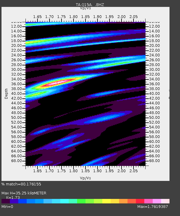
| Estimated Moho Depth: |
35.25 km |
| Estimated Crust Vp/Vs: |
1.73 |
| Assumed Crust Vp: |
6.276 km/s |
| Estimated Crust Vs: |
3.628 km/s |
| Estimated Crust Poisson's Ratio: |
0.25 |
|
| Radial Match: |
80.176155 % |
| Radial Bump: |
400 |
| Transverse Match: |
75.5958 % |
| Transverse Bump: |
399 |
| SOD ConfigId: |
2504 |
| Insert Time: |
2010-03-06 05:43:13.215 +0000 |
| GWidth: |
2.5 |
| Max Bumps: |
400 |
| Tol: |
0.001 |
|
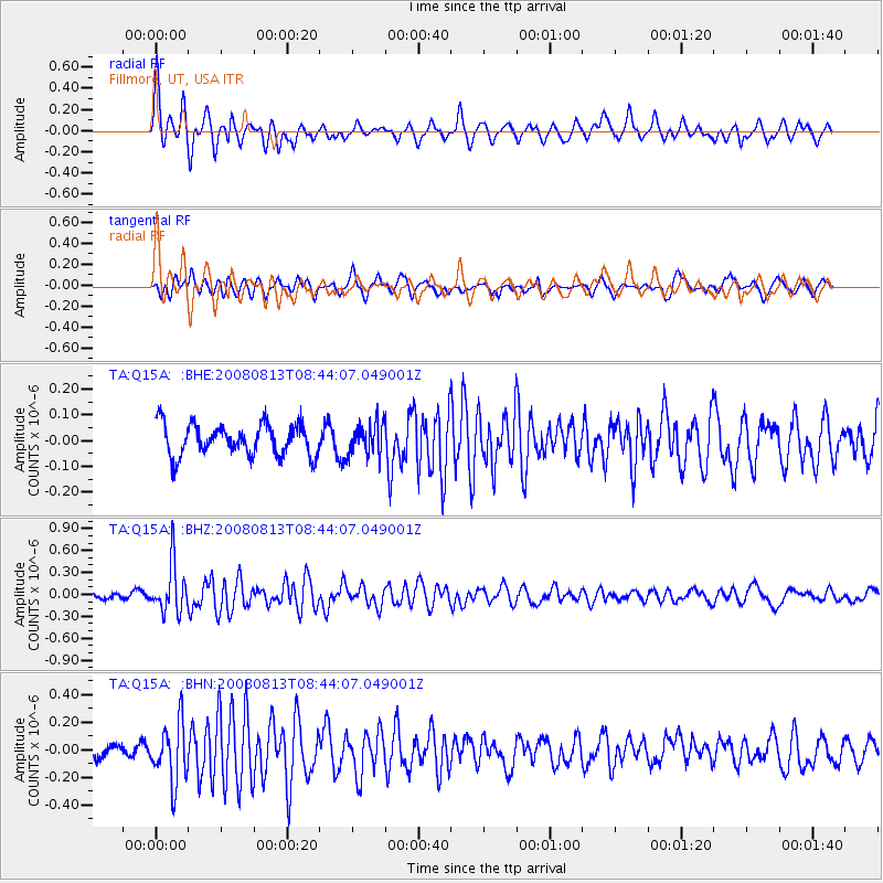
Signal To Noise
| Channel | StoN | STA | LTA |
| TA:Q15A: :BHZ:20080813T08:44:07.049001Z | 9.816914 | 3.2799954E-7 | 3.3411677E-8 |
| TA:Q15A: :BHN:20080813T08:44:07.049001Z | 5.034301 | 2.1495714E-7 | 4.269851E-8 |
| TA:Q15A: :BHE:20080813T08:44:07.049001Z | 1.0321138 | 6.275674E-8 | 6.080408E-8 |
| Arrivals |
| Ps | 4.3 SECOND |
| PpPs | 15 SECOND |
| PsPs/PpSs | 19 SECOND |


