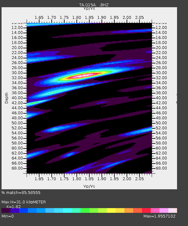
Q15A Fillmore, UT, USA - Earthquake Result Viewer
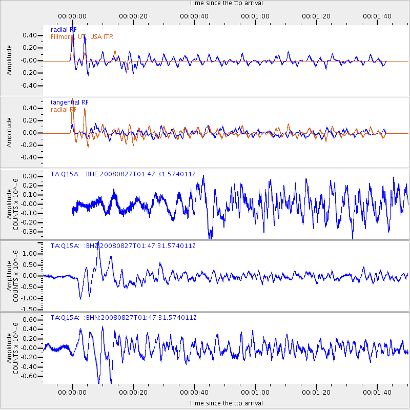
Earthquake location: Lake Baykal Region, Russia
Earthquake latitude/longitude: 51.6/104.2
Earthquake time(UTC): 2008/08/27 (240) 01:35:32 GMT
Earthquake Depth: 16 km
Earthquake Magnitude: 5.8 MB, 6.2 MS, 6.2 MW, 6.2 MW
Earthquake Catalog/Contributor: WHDF/NEIC
Network: TA USArray Transportable Network (new EarthScope stations)
Station: Q15A Fillmore, UT, USA
Lat/Lon: 39.00 N/112.38 W
Elevation: 1477 m
Distance: 84.3 deg
Az: 27.789 deg
Baz: 338.092 deg
Ray Param: 0.045579817
Estimated Moho Depth: 31.0 km
Estimated Crust Vp/Vs: 1.82
Assumed Crust Vp: 6.276 km/s
Estimated Crust Vs: 3.448 km/s
Estimated Crust Poisson's Ratio: 0.28
Radial Match: 85.58555 %
Radial Bump: 400
Transverse Match: 77.75971 %
Transverse Bump: 400
SOD ConfigId: 2504
Insert Time: 2010-03-06 05:43:16.830 +0000
GWidth: 2.5
Max Bumps: 400
Tol: 0.001

Signal To Noise

ChannelStoNSTALTA
TA:Q15A: :BHZ:20080827T01:47:31.574011Z8.3140864.0229696E-74.8387395E-8
TA:Q15A: :BHN:20080827T01:47:31.574011Z3.12247971.897017E-76.075354E-8
TA:Q15A: :BHE:20080827T01:47:31.574011Z1.66629568.824433E-85.2958388E-8
Arrivals
Ps4.1 SECOND
PpPs14 SECOND
PsPs/PpSs18 SECOND