You are here: Home > Network List > TA - USArray Transportable Network (new EarthScope stations) Stations List
> Station Q15A Fillmore, UT, USA > Earthquake Result Viewer
Q15A Fillmore, UT, USA - Earthquake Result Viewer

| Earthquake location: |
Virgin Islands |
| Earthquake latitude/longitude: |
19.2/-64.8 |
| Earthquake time(UTC): |
2008/10/11 (285) 10:40:14 GMT |
| Earthquake Depth: |
23 km |
| Earthquake Magnitude: |
6.1 MB, 5.9 MS, 6.1 MW, 6.0 MW |
| Earthquake Catalog/Contributor: |
WHDF/NEIC |
|
| Network: |
TA USArray Transportable Network (new EarthScope stations) |
| Station: |
Q15A Fillmore, UT, USA |
| Lat/Lon: |
39.00 N/112.38 W |
| Elevation: |
1477 m |
|
| Distance: |
45.4 deg |
| Az: |
306.205 deg |
| Baz: |
101.798 deg |
| Ray Param: |
0.07124113 |
| Estimated Moho Depth: |
35.5 km |
| Estimated Crust Vp/Vs: |
1.66 |
| Assumed Crust Vp: |
6.276 km/s |
| Estimated Crust Vs: |
3.786 km/s |
| Estimated Crust Poisson's Ratio: |
0.21 |
|
| Radial Match: |
85.8659 % |
| Radial Bump: |
400 |
| Transverse Match: |
78.56209 % |
| Transverse Bump: |
400 |
| SOD ConfigId: |
2556 |
| Insert Time: |
2010-03-06 05:43:20.693 +0000 |
| GWidth: |
2.5 |
| Max Bumps: |
400 |
| Tol: |
0.001 |
|
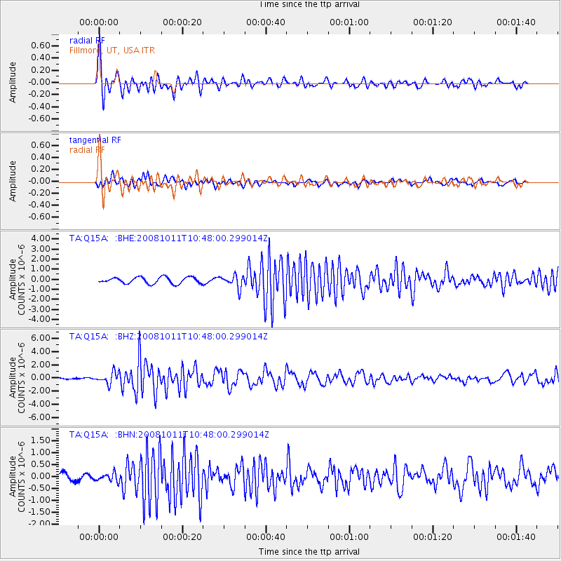
Signal To Noise
| Channel | StoN | STA | LTA |
| TA:Q15A: :BHZ:20081011T10:48:00.299014Z | 8.760004 | 8.912799E-7 | 1.01744234E-7 |
| TA:Q15A: :BHN:20081011T10:48:00.299014Z | 1.0099063 | 1.698521E-7 | 1.6818599E-7 |
| TA:Q15A: :BHE:20081011T10:48:00.299014Z | 2.0467641 | 6.4094814E-7 | 3.1315193E-7 |
| Arrivals |
| Ps | 4.0 SECOND |
| PpPs | 14 SECOND |
| PsPs/PpSs | 18 SECOND |


