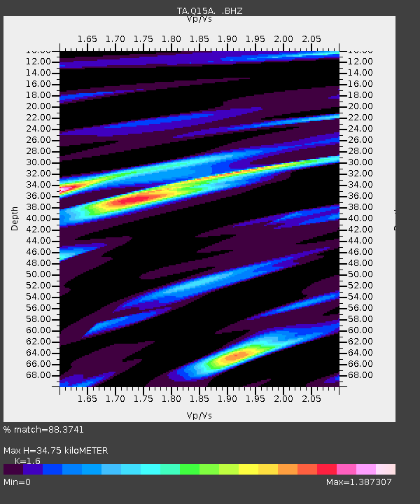
Q15A Fillmore, UT, USA - Earthquake Result Viewer
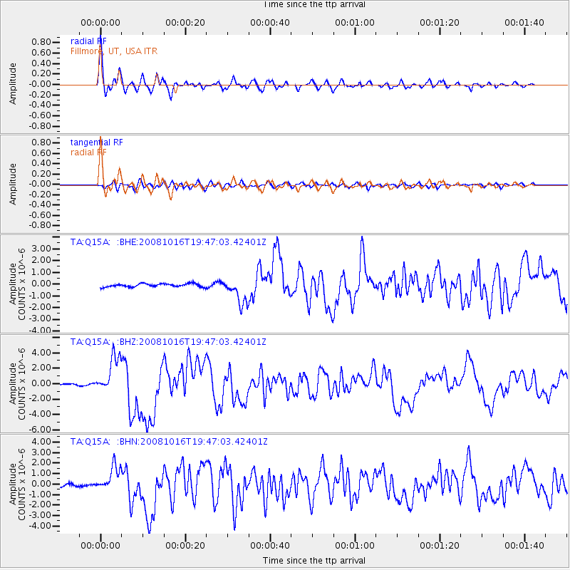
Earthquake location: Near Coast Of Chiapas, Mexico
Earthquake latitude/longitude: 14.4/-92.4
Earthquake time(UTC): 2008/10/16 (290) 19:41:25 GMT
Earthquake Depth: 24 km
Earthquake Magnitude: 6.1 MB, 6.6 MS, 6.7 MW, 6.6 MW
Earthquake Catalog/Contributor: WHDF/NEIC
Network: TA USArray Transportable Network (new EarthScope stations)
Station: Q15A Fillmore, UT, USA
Lat/Lon: 39.00 N/112.38 W
Elevation: 1477 m
Distance: 30.2 deg
Az: 327.953 deg
Baz: 138.718 deg
Ray Param: 0.07938327
Estimated Moho Depth: 34.75 km
Estimated Crust Vp/Vs: 1.60
Assumed Crust Vp: 6.276 km/s
Estimated Crust Vs: 3.922 km/s
Estimated Crust Poisson's Ratio: 0.18
Radial Match: 88.3741 %
Radial Bump: 400
Transverse Match: 73.871994 %
Transverse Bump: 400
SOD ConfigId: 2556
Insert Time: 2010-03-06 05:43:25.752 +0000
GWidth: 2.5
Max Bumps: 400
Tol: 0.001

Signal To Noise

ChannelStoNSTALTA
TA:Q15A: :BHZ:20081016T19:47:03.42401Z29.8326932.4993499E-68.3778886E-8
TA:Q15A: :BHN:20081016T19:47:03.42401Z11.6810471.211366E-61.0370354E-7
TA:Q15A: :BHE:20081016T19:47:03.42401Z8.2061951.1294785E-61.3763731E-7
Arrivals
Ps3.6 SECOND
PpPs13 SECOND
PsPs/PpSs17 SECOND