You are here: Home > Network List > KS - Korea National Seismograph Network- KMA Stations List
> Station NAWB Namwon, South Korea > Earthquake Result Viewer
NAWB Namwon, South Korea - Earthquake Result Viewer
| Earthquake location: |
Seram, Indonesia |
| Earthquake latitude/longitude: |
-3.7/127.8 |
| Earthquake time(UTC): |
2017/10/31 (304) 11:50:51 GMT |
| Earthquake Depth: |
32 km |
| Earthquake Magnitude: |
6.3 Mww |
| Earthquake Catalog/Contributor: |
NEIC PDE/us |
|
| Network: |
KS Korea National Seismograph Network- KMA |
| Station: |
NAWB Namwon, South Korea |
| Lat/Lon: |
35.42 N/127.40 E |
| Elevation: |
176 m |
|
| Distance: |
38.9 deg |
| Az: |
359.455 deg |
| Baz: |
179.334 deg |
| Ray Param: |
0.07522272 |
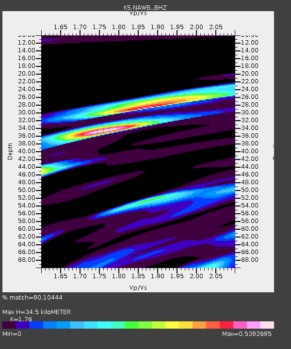
| Estimated Moho Depth: |
34.5 km |
| Estimated Crust Vp/Vs: |
1.76 |
| Assumed Crust Vp: |
6.459 km/s |
| Estimated Crust Vs: |
3.67 km/s |
| Estimated Crust Poisson's Ratio: |
0.26 |
|
| Radial Match: |
90.10444 % |
| Radial Bump: |
266 |
| Transverse Match: |
69.01514 % |
| Transverse Bump: |
400 |
| SOD ConfigId: |
13570011 |
| Insert Time: |
2019-04-29 01:45:59.728 +0000 |
| GWidth: |
2.5 |
| Max Bumps: |
400 |
| Tol: |
0.001 |
|

Signal To Noise
| Channel | StoN | STA | LTA |
| KS:NAWB: :BHZ:20171031T11:57:44.469014Z | 3.0260038 | 1.2892892E-6 | 4.2606993E-7 |
| KS:NAWB: :BHN:20171031T11:57:44.469014Z | 2.9975877 | 8.3877126E-7 | 2.7981542E-7 |
| KS:NAWB: :BHE:20171031T11:57:44.469014Z | 1.4637808 | 4.64381E-7 | 3.1724764E-7 |
| Arrivals |
| Ps | 4.4 SECOND |
| PpPs | 14 SECOND |
| PsPs/PpSs | 18 SECOND |


