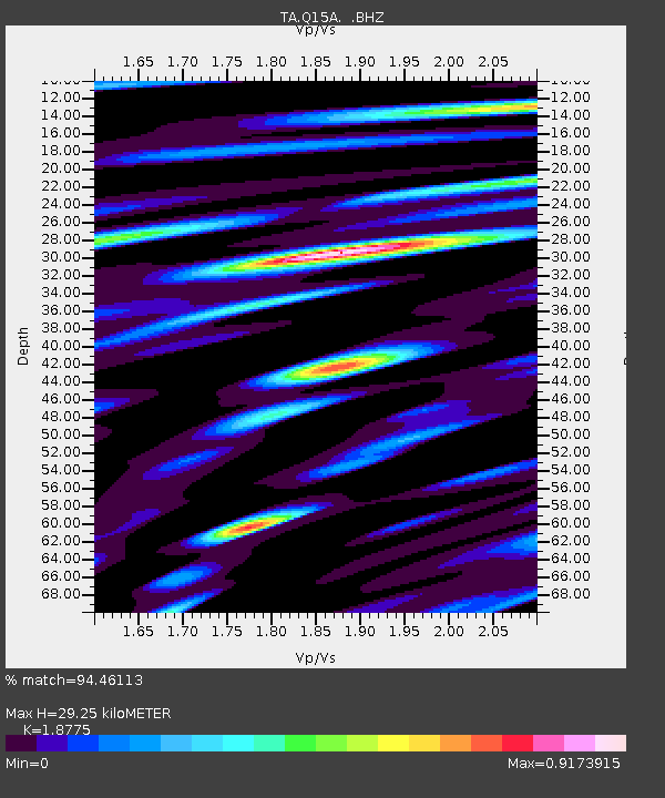
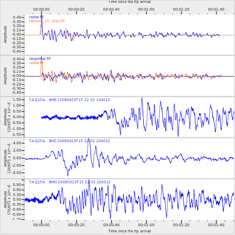
Q15A Fillmore, UT, USA - Earthquake Result Viewer

Earthquake location: Kermadec Islands, New Zealand
Earthquake latitude/longitude: -29.8/-177.7
Earthquake time(UTC): 2008/09/29 (273) 15:19:31 GMT
Earthquake Depth: 36 km
Earthquake Magnitude: 6.5 MB, 6.7 MS, 7.0 MW, 7.0 MW
Earthquake Catalog/Contributor: WHDF/NEIC
Network: TA USArray Transportable Network (new EarthScope stations)
Station: Q15A Fillmore, UT, USA
Lat/Lon: 39.00 N/112.38 W
Elevation: 1477 m
Distance: 91.5 deg
Az: 45.088 deg
Baz: 232.215 deg
Ray Param: 0.04158881
Estimated Moho Depth: 29.25 km
Estimated Crust Vp/Vs: 1.88
Assumed Crust Vp: 6.276 km/s
Estimated Crust Vs: 3.343 km/s
Estimated Crust Poisson's Ratio: 0.30
Radial Match: 94.46113 %
Radial Bump: 400
Transverse Match: 89.80821 %
Transverse Bump: 400
SOD ConfigId: 2560
Insert Time: 2010-03-06 05:43:40.356 +0000
GWidth: 2.5
Max Bumps: 400
Tol: 0.001

Signal To Noise

ChannelStoNSTALTA
TA:Q15A: :BHZ:20080929T15:32:03.10001Z4.7668824.1071968E-78.616107E-8
TA:Q15A: :BHN:20080929T15:32:03.10001Z1.17450181.15838446E-79.862773E-8
TA:Q15A: :BHE:20080929T15:32:03.10001Z1.56696141.3752548E-78.7765706E-8
Arrivals
Ps4.2 SECOND
PpPs13 SECOND
PsPs/PpSs17 SECOND