You are here: Home > Network List > US - United States National Seismic Network Stations List
> Station AMTX Amarillo, Texas, USA > Earthquake Result Viewer
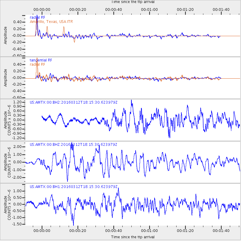
AMTX Amarillo, Texas, USA - Earthquake Result Viewer
*The percent match for this event was below the threshold and hence no stack was calculated.
| Earthquake location: |
Andreanof Islands, Aleutian Is. |
| Earthquake latitude/longitude: |
51.6/-174.0 |
| Earthquake time(UTC): |
2016/03/12 (072) 18:06:45 GMT |
| Earthquake Depth: |
19 km |
| Earthquake Magnitude: |
6.3 MWW, 6.1 MB, 6.2 MWB, 6.3 MWC, 6.4 MWC, 6.4 MI |
| Earthquake Catalog/Contributor: |
NEIC PDE/NEIC COMCAT |
|
| Network: |
US United States National Seismic Network |
| Station: |
AMTX Amarillo, Texas, USA |
| Lat/Lon: |
34.53 N/101.41 W |
| Elevation: |
1010 m |
|
| Distance: |
53.5 deg |
| Az: |
78.552 deg |
| Baz: |
312.178 deg |
| Ray Param: |
$rayparam |
*The percent match for this event was below the threshold and hence was not used in the summary stack. |
|
| Radial Match: |
83.39434 % |
| Radial Bump: |
400 |
| Transverse Match: |
64.19013 % |
| Transverse Bump: |
400 |
| SOD ConfigId: |
1475611 |
| Insert Time: |
2016-04-11 15:08:58.924 +0000 |
| GWidth: |
2.5 |
| Max Bumps: |
400 |
| Tol: |
0.001 |
|
Signal To Noise
| Channel | StoN | STA | LTA |
| US:AMTX:00:BHZ:20160312T18:15:30.623979Z | 3.79197 | 6.512664E-7 | 1.7174884E-7 |
| US:AMTX:00:BH1:20160312T18:15:30.623979Z | 1.4909726 | 2.3658598E-7 | 1.5867896E-7 |
| US:AMTX:00:BH2:20160312T18:15:30.623979Z | 1.3527676 | 2.594964E-7 | 1.918263E-7 |
| Arrivals |
| Ps | |
| PpPs | |
| PsPs/PpSs | |


