You are here: Home > Network List > TA - USArray Transportable Network (new EarthScope stations) Stations List
> Station D17K Noatak River, AK, USA > Earthquake Result Viewer
D17K Noatak River, AK, USA - Earthquake Result Viewer
| Earthquake location: |
Seram, Indonesia |
| Earthquake latitude/longitude: |
-3.7/127.8 |
| Earthquake time(UTC): |
2017/10/31 (304) 11:50:51 GMT |
| Earthquake Depth: |
32 km |
| Earthquake Magnitude: |
6.3 Mww |
| Earthquake Catalog/Contributor: |
NEIC PDE/us |
|
| Network: |
TA USArray Transportable Network (new EarthScope stations) |
| Station: |
D17K Noatak River, AK, USA |
| Lat/Lon: |
67.70 N/163.08 W |
| Elevation: |
172 m |
|
| Distance: |
85.6 deg |
| Az: |
20.953 deg |
| Baz: |
249.234 deg |
| Ray Param: |
0.04460128 |
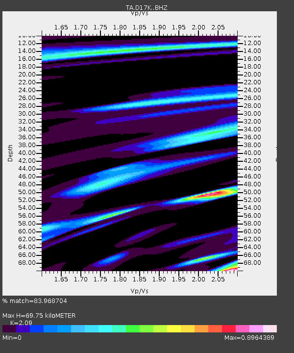
| Estimated Moho Depth: |
69.75 km |
| Estimated Crust Vp/Vs: |
2.09 |
| Assumed Crust Vp: |
6.276 km/s |
| Estimated Crust Vs: |
3.003 km/s |
| Estimated Crust Poisson's Ratio: |
0.35 |
|
| Radial Match: |
83.968704 % |
| Radial Bump: |
400 |
| Transverse Match: |
82.826965 % |
| Transverse Bump: |
400 |
| SOD ConfigId: |
13570011 |
| Insert Time: |
2019-04-29 01:46:39.008 +0000 |
| GWidth: |
2.5 |
| Max Bumps: |
400 |
| Tol: |
0.001 |
|

Signal To Noise
| Channel | StoN | STA | LTA |
| TA:D17K: :BHZ:20171031T12:02:56.37502Z | 5.4445724 | 7.956835E-7 | 1.4614251E-7 |
| TA:D17K: :BHN:20171031T12:02:56.37502Z | 0.76120585 | 1.6530213E-7 | 2.1715825E-7 |
| TA:D17K: :BHE:20171031T12:02:56.37502Z | 0.8458461 | 1.309148E-7 | 1.5477377E-7 |
| Arrivals |
| Ps | 12 SECOND |
| PpPs | 34 SECOND |
| PsPs/PpSs | 46 SECOND |


