You are here: Home > Network List > TA - USArray Transportable Network (new EarthScope stations) Stations List
> Station H31M Peel River, Yukon, CAN > Earthquake Result Viewer
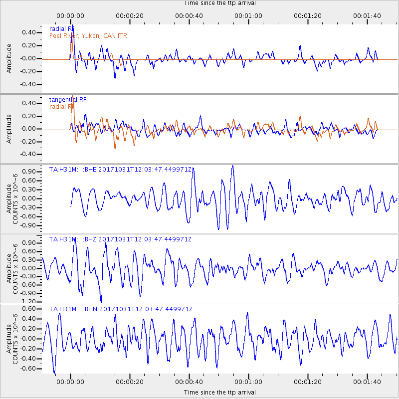
H31M Peel River, Yukon, CAN - Earthquake Result Viewer
*The percent match for this event was below the threshold and hence no stack was calculated.
| Earthquake location: |
Seram, Indonesia |
| Earthquake latitude/longitude: |
-3.7/127.8 |
| Earthquake time(UTC): |
2017/10/31 (304) 11:50:51 GMT |
| Earthquake Depth: |
32 km |
| Earthquake Magnitude: |
6.3 Mww |
| Earthquake Catalog/Contributor: |
NEIC PDE/us |
|
| Network: |
TA USArray Transportable Network (new EarthScope stations) |
| Station: |
H31M Peel River, Yukon, CAN |
| Lat/Lon: |
65.81 N/134.34 W |
| Elevation: |
642 m |
|
| Distance: |
96.6 deg |
| Az: |
24.267 deg |
| Baz: |
275.64 deg |
| Ray Param: |
$rayparam |
*The percent match for this event was below the threshold and hence was not used in the summary stack. |
|
| Radial Match: |
63.99006 % |
| Radial Bump: |
400 |
| Transverse Match: |
44.681995 % |
| Transverse Bump: |
400 |
| SOD ConfigId: |
13570011 |
| Insert Time: |
2019-04-29 01:47:20.529 +0000 |
| GWidth: |
2.5 |
| Max Bumps: |
400 |
| Tol: |
0.001 |
|
Signal To Noise
| Channel | StoN | STA | LTA |
| TA:H31M: :BHZ:20171031T12:03:47.449971Z | 3.1358683 | 6.181386E-7 | 1.9711881E-7 |
| TA:H31M: :BHN:20171031T12:03:47.449971Z | 0.49859235 | 1.53364E-7 | 3.0759398E-7 |
| TA:H31M: :BHE:20171031T12:03:47.449971Z | 1.4788512 | 3.3365066E-7 | 2.2561476E-7 |
| Arrivals |
| Ps | |
| PpPs | |
| PsPs/PpSs | |


