You are here: Home > Network List > TA - USArray Transportable Network (new EarthScope stations) Stations List
> Station I23K Minto, Yukon-Koyukuk, AK, USA > Earthquake Result Viewer
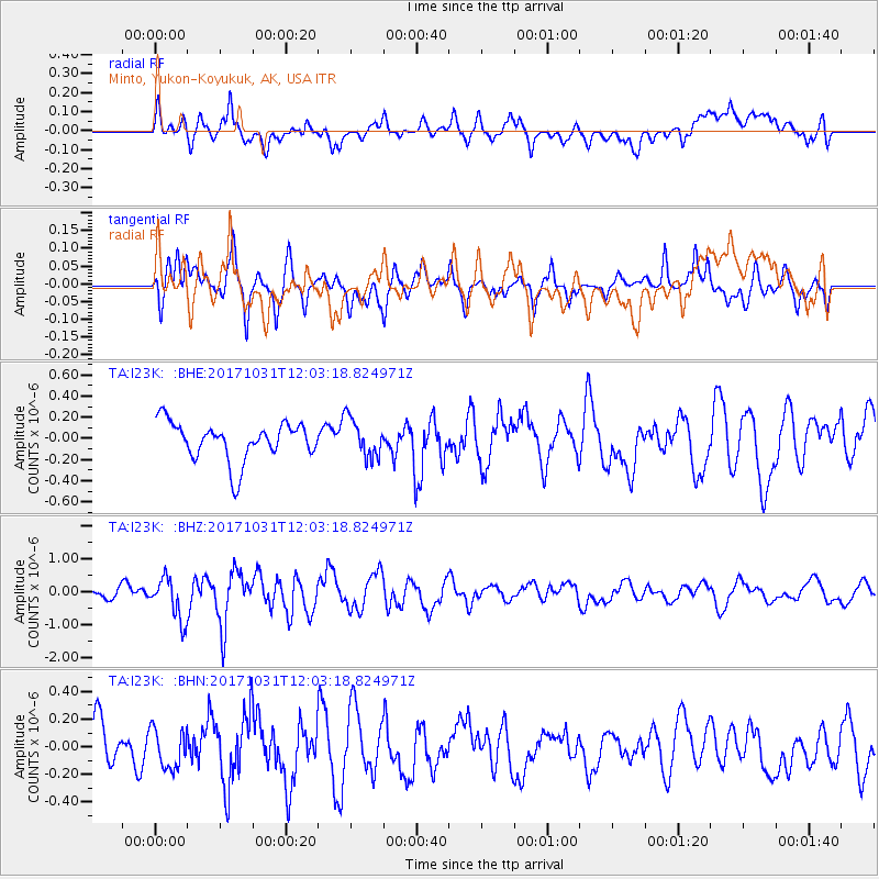
I23K Minto, Yukon-Koyukuk, AK, USA - Earthquake Result Viewer
*The percent match for this event was below the threshold and hence no stack was calculated.
| Earthquake location: |
Seram, Indonesia |
| Earthquake latitude/longitude: |
-3.7/127.8 |
| Earthquake time(UTC): |
2017/10/31 (304) 11:50:51 GMT |
| Earthquake Depth: |
32 km |
| Earthquake Magnitude: |
6.3 Mww |
| Earthquake Catalog/Contributor: |
NEIC PDE/us |
|
| Network: |
TA USArray Transportable Network (new EarthScope stations) |
| Station: |
I23K Minto, Yukon-Koyukuk, AK, USA |
| Lat/Lon: |
65.15 N/149.36 W |
| Elevation: |
149 m |
|
| Distance: |
90.3 deg |
| Az: |
24.79 deg |
| Baz: |
261.947 deg |
| Ray Param: |
$rayparam |
*The percent match for this event was below the threshold and hence was not used in the summary stack. |
|
| Radial Match: |
54.07755 % |
| Radial Bump: |
400 |
| Transverse Match: |
52.03978 % |
| Transverse Bump: |
338 |
| SOD ConfigId: |
13570011 |
| Insert Time: |
2019-04-29 01:47:24.483 +0000 |
| GWidth: |
2.5 |
| Max Bumps: |
400 |
| Tol: |
0.001 |
|
Signal To Noise
| Channel | StoN | STA | LTA |
| TA:I23K: :BHZ:20171031T12:03:18.824971Z | 3.8473883 | 6.398486E-7 | 1.6630727E-7 |
| TA:I23K: :BHN:20171031T12:03:18.824971Z | 0.7957468 | 1.4237894E-7 | 1.7892494E-7 |
| TA:I23K: :BHE:20171031T12:03:18.824971Z | 1.0484488 | 1.9036415E-7 | 1.8156742E-7 |
| Arrivals |
| Ps | |
| PpPs | |
| PsPs/PpSs | |


