You are here: Home > Network List > TA - USArray Transportable Network (new EarthScope stations) Stations List
> Station K13K Kusilvak Mountain, AK, USA > Earthquake Result Viewer
K13K Kusilvak Mountain, AK, USA - Earthquake Result Viewer
| Earthquake location: |
Seram, Indonesia |
| Earthquake latitude/longitude: |
-3.7/127.8 |
| Earthquake time(UTC): |
2017/10/31 (304) 11:50:51 GMT |
| Earthquake Depth: |
32 km |
| Earthquake Magnitude: |
6.3 Mww |
| Earthquake Catalog/Contributor: |
NEIC PDE/us |
|
| Network: |
TA USArray Transportable Network (new EarthScope stations) |
| Station: |
K13K Kusilvak Mountain, AK, USA |
| Lat/Lon: |
61.93 N/164.66 W |
| Elevation: |
204 m |
|
| Distance: |
82.9 deg |
| Az: |
26.132 deg |
| Baz: |
248.331 deg |
| Ray Param: |
0.046536107 |
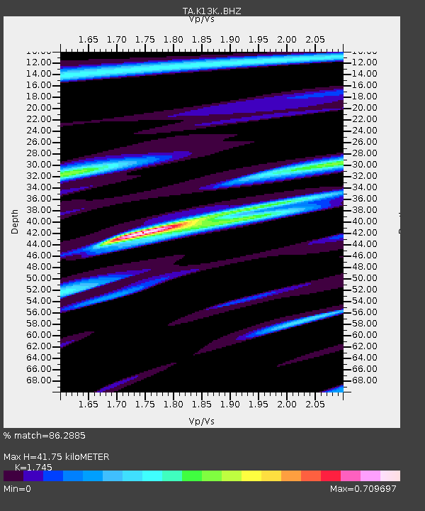
| Estimated Moho Depth: |
41.75 km |
| Estimated Crust Vp/Vs: |
1.75 |
| Assumed Crust Vp: |
6.1 km/s |
| Estimated Crust Vs: |
3.496 km/s |
| Estimated Crust Poisson's Ratio: |
0.26 |
|
| Radial Match: |
86.2885 % |
| Radial Bump: |
400 |
| Transverse Match: |
68.076485 % |
| Transverse Bump: |
400 |
| SOD ConfigId: |
13570011 |
| Insert Time: |
2019-04-29 01:47:35.399 +0000 |
| GWidth: |
2.5 |
| Max Bumps: |
400 |
| Tol: |
0.001 |
|

Signal To Noise
| Channel | StoN | STA | LTA |
| TA:K13K: :BHZ:20171031T12:02:42.62502Z | 6.9798603 | 1.1523438E-6 | 1.6509554E-7 |
| TA:K13K: :BHN:20171031T12:02:42.62502Z | 1.3041167 | 3.2166304E-7 | 2.4665204E-7 |
| TA:K13K: :BHE:20171031T12:02:42.62502Z | 1.5019253 | 3.3555634E-7 | 2.2341747E-7 |
| Arrivals |
| Ps | 5.2 SECOND |
| PpPs | 18 SECOND |
| PsPs/PpSs | 24 SECOND |


