You are here: Home > Network List > TA - USArray Transportable Network (new EarthScope stations) Stations List
> Station L17K Donlin, AK, USA > Earthquake Result Viewer
L17K Donlin, AK, USA - Earthquake Result Viewer
| Earthquake location: |
Seram, Indonesia |
| Earthquake latitude/longitude: |
-3.7/127.8 |
| Earthquake time(UTC): |
2017/10/31 (304) 11:50:51 GMT |
| Earthquake Depth: |
32 km |
| Earthquake Magnitude: |
6.3 Mww |
| Earthquake Catalog/Contributor: |
NEIC PDE/us |
|
| Network: |
TA USArray Transportable Network (new EarthScope stations) |
| Station: |
L17K Donlin, AK, USA |
| Lat/Lon: |
62.13 N/158.30 W |
| Elevation: |
338 m |
|
| Distance: |
85.8 deg |
| Az: |
26.912 deg |
| Baz: |
254.017 deg |
| Ray Param: |
0.04447519 |
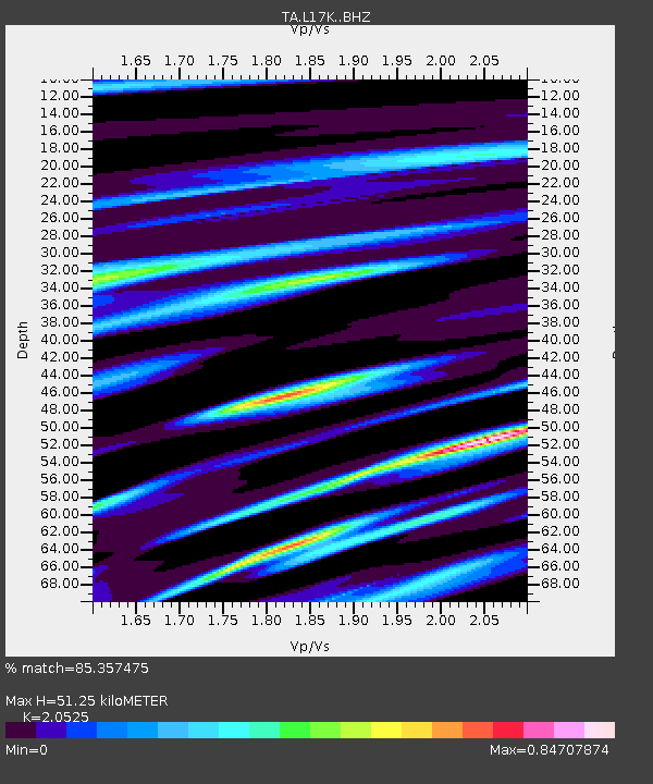
| Estimated Moho Depth: |
51.25 km |
| Estimated Crust Vp/Vs: |
2.05 |
| Assumed Crust Vp: |
6.276 km/s |
| Estimated Crust Vs: |
3.058 km/s |
| Estimated Crust Poisson's Ratio: |
0.34 |
|
| Radial Match: |
85.357475 % |
| Radial Bump: |
400 |
| Transverse Match: |
59.824398 % |
| Transverse Bump: |
400 |
| SOD ConfigId: |
13570011 |
| Insert Time: |
2019-04-29 01:47:44.639 +0000 |
| GWidth: |
2.5 |
| Max Bumps: |
400 |
| Tol: |
0.001 |
|

Signal To Noise
| Channel | StoN | STA | LTA |
| TA:L17K: :BHZ:20171031T12:02:57.274983Z | 4.35237 | 7.2330175E-7 | 1.6618574E-7 |
| TA:L17K: :BHN:20171031T12:02:57.274983Z | 0.76400656 | 1.8365853E-7 | 2.403887E-7 |
| TA:L17K: :BHE:20171031T12:02:57.274983Z | 1.1599051 | 2.6618986E-7 | 2.294928E-7 |
| Arrivals |
| Ps | 8.8 SECOND |
| PpPs | 24 SECOND |
| PsPs/PpSs | 33 SECOND |


