You are here: Home > Network List > TA - USArray Transportable Network (new EarthScope stations) Stations List
> Station Q15A Fillmore, UT, USA > Earthquake Result Viewer
Q15A Fillmore, UT, USA - Earthquake Result Viewer
| Earthquake location: |
Sea Of Japan |
| Earthquake latitude/longitude: |
36.8/134.9 |
| Earthquake time(UTC): |
2007/07/16 (197) 14:17:37 GMT |
| Earthquake Depth: |
350 km |
| Earthquake Magnitude: |
6.2 MB, 6.8 MW, 6.8 MW |
| Earthquake Catalog/Contributor: |
WHDF/NEIC |
|
| Network: |
TA USArray Transportable Network (new EarthScope stations) |
| Station: |
Q15A Fillmore, UT, USA |
| Lat/Lon: |
39.00 N/112.38 W |
| Elevation: |
1477 m |
|
| Distance: |
82.4 deg |
| Az: |
46.453 deg |
| Baz: |
311.709 deg |
| Ray Param: |
0.04596764 |
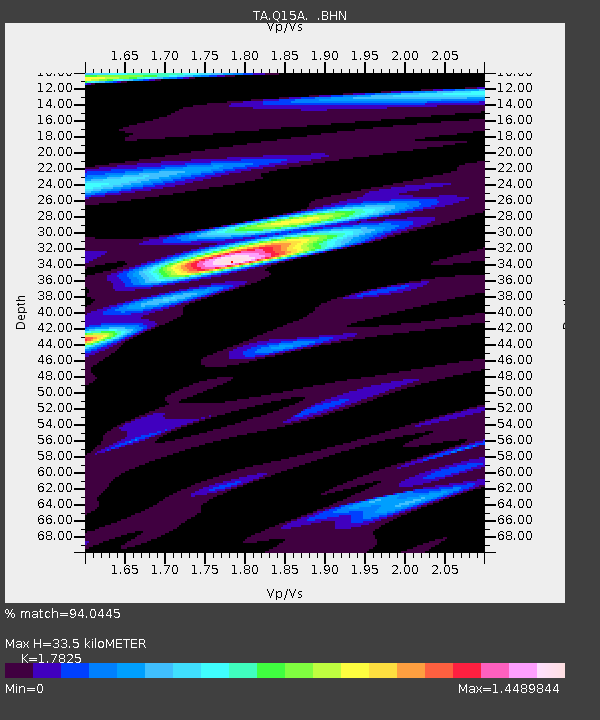
| Estimated Moho Depth: |
33.5 km |
| Estimated Crust Vp/Vs: |
1.78 |
| Assumed Crust Vp: |
6.276 km/s |
| Estimated Crust Vs: |
3.521 km/s |
| Estimated Crust Poisson's Ratio: |
0.27 |
|
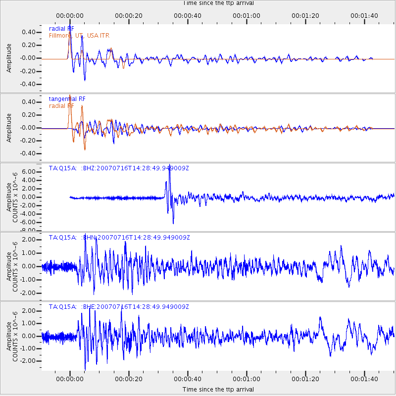
| Radial Match: |
94.0445 % |
| Radial Bump: |
400 |
| Transverse Match: |
86.286 % |
| Transverse Bump: |
400 |
| SOD ConfigId: |
2564 |
| Insert Time: |
2010-03-06 05:44:40.744 +0000 |
| GWidth: |
2.5 |
| Max Bumps: |
400 |
| Tol: |
0.001 |
|
Signal To Noise
| Channel | StoN | STA | LTA |
| TA:Q15A: :BHN:20070716T14:28:49.949009Z | 2.5687108 | 5.1349144E-7 | 1.999024E-7 |
| TA:Q15A: :BHE:20070716T14:28:49.949009Z | 2.0909774 | 5.412933E-7 | 2.588709E-7 |
| TA:Q15A: :BHZ:20070716T14:28:49.949009Z | 18.149963 | 2.30231E-6 | 1.2684929E-7 |
| Arrivals |
| Ps | 4.3 SECOND |
| PpPs | 15 SECOND |
| PsPs/PpSs | 19 SECOND |


