You are here: Home > Network List > TA - USArray Transportable Network (new EarthScope stations) Stations List
> Station Q15A Fillmore, UT, USA > Earthquake Result Viewer
Q15A Fillmore, UT, USA - Earthquake Result Viewer
| Earthquake location: |
Kamchatka Peninsula, Russia |
| Earthquake latitude/longitude: |
52.1/157.3 |
| Earthquake time(UTC): |
2007/05/30 (150) 20:22:12 GMT |
| Earthquake Depth: |
116 km |
| Earthquake Magnitude: |
6.4 MB, 6.4 MW, 6.4 MW |
| Earthquake Catalog/Contributor: |
WHDF/NEIC |
|
| Network: |
TA USArray Transportable Network (new EarthScope stations) |
| Station: |
Q15A Fillmore, UT, USA |
| Lat/Lon: |
39.00 N/112.38 W |
| Elevation: |
1477 m |
|
| Distance: |
60.6 deg |
| Az: |
63.423 deg |
| Baz: |
314.976 deg |
| Ray Param: |
0.06108033 |
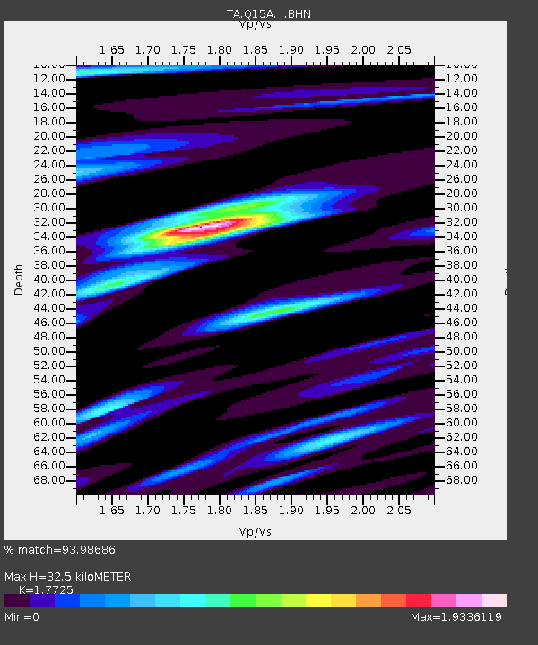
| Estimated Moho Depth: |
32.5 km |
| Estimated Crust Vp/Vs: |
1.77 |
| Assumed Crust Vp: |
6.276 km/s |
| Estimated Crust Vs: |
3.541 km/s |
| Estimated Crust Poisson's Ratio: |
0.27 |
|
| Radial Match: |
93.98686 % |
| Radial Bump: |
400 |
| Transverse Match: |
87.29955 % |
| Transverse Bump: |
400 |
| SOD ConfigId: |
2564 |
| Insert Time: |
2010-03-06 05:44:55.716 +0000 |
| GWidth: |
2.5 |
| Max Bumps: |
400 |
| Tol: |
0.001 |
|

Signal To Noise
| Channel | StoN | STA | LTA |
| TA:Q15A: :BHN:20070530T20:31:40.475002Z | 13.670774 | 1.5087168E-6 | 1.1036074E-7 |
| TA:Q15A: :BHE:20070530T20:31:40.475002Z | 11.772728 | 1.3533013E-6 | 1.1495223E-7 |
| TA:Q15A: :BHZ:20070530T20:31:40.475002Z | 44.34964 | 3.6995414E-6 | 8.341762E-8 |
| Arrivals |
| Ps | 4.2 SECOND |
| PpPs | 14 SECOND |
| PsPs/PpSs | 18 SECOND |


