You are here: Home > Network List > TA - USArray Transportable Network (new EarthScope stations) Stations List
> Station K15K Wolf Creek Mountain, AK, USA > Earthquake Result Viewer
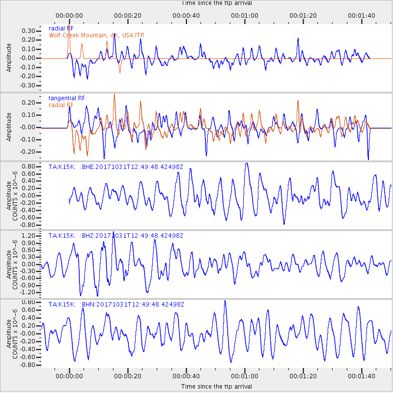
K15K Wolf Creek Mountain, AK, USA - Earthquake Result Viewer
*The percent match for this event was below the threshold and hence no stack was calculated.
| Earthquake location: |
Seram, Indonesia |
| Earthquake latitude/longitude: |
-3.8/127.8 |
| Earthquake time(UTC): |
2017/10/31 (304) 12:37:47 GMT |
| Earthquake Depth: |
16 km |
| Earthquake Magnitude: |
5.7 Mww |
| Earthquake Catalog/Contributor: |
NEIC PDE/us |
|
| Network: |
TA USArray Transportable Network (new EarthScope stations) |
| Station: |
K15K Wolf Creek Mountain, AK, USA |
| Lat/Lon: |
62.29 N/161.53 W |
| Elevation: |
346 m |
|
| Distance: |
84.5 deg |
| Az: |
26.305 deg |
| Baz: |
251.097 deg |
| Ray Param: |
$rayparam |
*The percent match for this event was below the threshold and hence was not used in the summary stack. |
|
| Radial Match: |
71.1224 % |
| Radial Bump: |
400 |
| Transverse Match: |
74.0186 % |
| Transverse Bump: |
400 |
| SOD ConfigId: |
13570011 |
| Insert Time: |
2019-04-29 01:51:10.648 +0000 |
| GWidth: |
2.5 |
| Max Bumps: |
400 |
| Tol: |
0.001 |
|
Signal To Noise
| Channel | StoN | STA | LTA |
| TA:K15K: :BHZ:20171031T12:49:48.42498Z | 2.2886968 | 6.883079E-7 | 3.007423E-7 |
| TA:K15K: :BHN:20171031T12:49:48.42498Z | 1.8431815 | 4.375413E-7 | 2.3738373E-7 |
| TA:K15K: :BHE:20171031T12:49:48.42498Z | 1.3498856 | 2.6178665E-7 | 1.9393248E-7 |
| Arrivals |
| Ps | |
| PpPs | |
| PsPs/PpSs | |


