You are here: Home > Network List > TA - USArray Transportable Network (new EarthScope stations) Stations List
> Station R31K City Hall, Gustavus, AK, USA > Earthquake Result Viewer
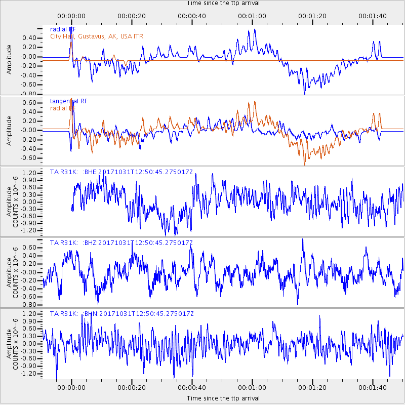
R31K City Hall, Gustavus, AK, USA - Earthquake Result Viewer
*The percent match for this event was below the threshold and hence no stack was calculated.
| Earthquake location: |
Seram, Indonesia |
| Earthquake latitude/longitude: |
-3.8/127.8 |
| Earthquake time(UTC): |
2017/10/31 (304) 12:37:47 GMT |
| Earthquake Depth: |
16 km |
| Earthquake Magnitude: |
5.7 Mww |
| Earthquake Catalog/Contributor: |
NEIC PDE/us |
|
| Network: |
TA USArray Transportable Network (new EarthScope stations) |
| Station: |
R31K City Hall, Gustavus, AK, USA |
| Lat/Lon: |
58.41 N/135.74 W |
| Elevation: |
15 m |
|
| Distance: |
96.6 deg |
| Az: |
31.769 deg |
| Baz: |
273.526 deg |
| Ray Param: |
$rayparam |
*The percent match for this event was below the threshold and hence was not used in the summary stack. |
|
| Radial Match: |
48.747334 % |
| Radial Bump: |
400 |
| Transverse Match: |
47.90628 % |
| Transverse Bump: |
400 |
| SOD ConfigId: |
13570011 |
| Insert Time: |
2019-04-29 01:51:23.419 +0000 |
| GWidth: |
2.5 |
| Max Bumps: |
400 |
| Tol: |
0.001 |
|
Signal To Noise
| Channel | StoN | STA | LTA |
| TA:R31K: :BHZ:20171031T12:50:45.275017Z | 1.2255615 | 3.4072042E-7 | 2.7801167E-7 |
| TA:R31K: :BHN:20171031T12:50:45.275017Z | 1.2113041 | 4.2733168E-7 | 3.5278646E-7 |
| TA:R31K: :BHE:20171031T12:50:45.275017Z | 2.2455997 | 1.0668168E-6 | 4.7506992E-7 |
| Arrivals |
| Ps | |
| PpPs | |
| PsPs/PpSs | |


