You are here: Home > Network List > US - United States National Seismic Network Stations List
> Station DGMT Dagmar, Montana, USA > Earthquake Result Viewer
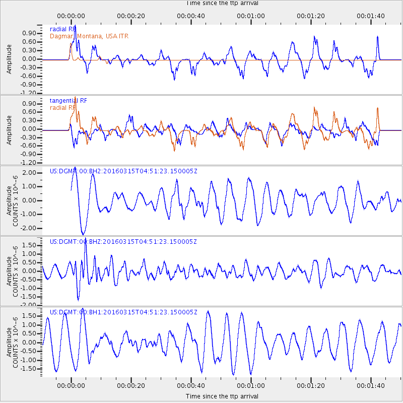
DGMT Dagmar, Montana, USA - Earthquake Result Viewer
*The percent match for this event was below the threshold and hence no stack was calculated.
| Earthquake location: |
Strait Of Gibraltar |
| Earthquake latitude/longitude: |
35.8/-3.6 |
| Earthquake time(UTC): |
2016/03/15 (075) 04:40:40 GMT |
| Earthquake Depth: |
10 km |
| Earthquake Magnitude: |
5.6 MB |
| Earthquake Catalog/Contributor: |
NEIC PDE/NEIC COMCAT |
|
| Network: |
US United States National Seismic Network |
| Station: |
DGMT Dagmar, Montana, USA |
| Lat/Lon: |
48.47 N/104.20 W |
| Elevation: |
0.0 m |
|
| Distance: |
70.4 deg |
| Az: |
316.032 deg |
| Baz: |
58.049 deg |
| Ray Param: |
$rayparam |
*The percent match for this event was below the threshold and hence was not used in the summary stack. |
|
| Radial Match: |
71.30743 % |
| Radial Bump: |
400 |
| Transverse Match: |
60.859707 % |
| Transverse Bump: |
400 |
| SOD ConfigId: |
1475611 |
| Insert Time: |
2016-04-11 15:32:13.262 +0000 |
| GWidth: |
2.5 |
| Max Bumps: |
400 |
| Tol: |
0.001 |
|
Signal To Noise
| Channel | StoN | STA | LTA |
| US:DGMT:00:BHZ:20160315T04:51:23.150005Z | 2.9496973 | 8.151896E-7 | 2.763638E-7 |
| US:DGMT:00:BH1:20160315T04:51:23.150005Z | 2.0884757 | 1.1955447E-6 | 5.724484E-7 |
| US:DGMT:00:BH2:20160315T04:51:23.150005Z | 0.69621044 | 7.3136874E-7 | 1.0504995E-6 |
| Arrivals |
| Ps | |
| PpPs | |
| PsPs/PpSs | |


