You are here: Home > Network List > CI - Caltech Regional Seismic Network Stations List
> Station MPM Manuel Prospect Mine, California, USA > Earthquake Result Viewer
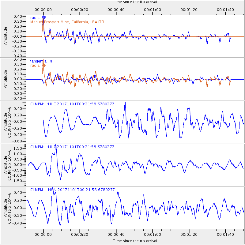
MPM Manuel Prospect Mine, California, USA - Earthquake Result Viewer
*The percent match for this event was below the threshold and hence no stack was calculated.
| Earthquake location: |
Loyalty Islands |
| Earthquake latitude/longitude: |
-21.7/168.9 |
| Earthquake time(UTC): |
2017/11/01 (305) 00:09:29 GMT |
| Earthquake Depth: |
10 km |
| Earthquake Magnitude: |
6.1 Mww |
| Earthquake Catalog/Contributor: |
NEIC PDE/us |
|
| Network: |
CI Caltech Regional Seismic Network |
| Station: |
MPM Manuel Prospect Mine, California, USA |
| Lat/Lon: |
36.06 N/117.49 W |
| Elevation: |
185 m |
|
| Distance: |
90.2 deg |
| Az: |
51.008 deg |
| Baz: |
243.106 deg |
| Ray Param: |
$rayparam |
*The percent match for this event was below the threshold and hence was not used in the summary stack. |
|
| Radial Match: |
70.66478 % |
| Radial Bump: |
400 |
| Transverse Match: |
56.88669 % |
| Transverse Bump: |
400 |
| SOD ConfigId: |
13570011 |
| Insert Time: |
2019-04-29 01:54:25.892 +0000 |
| GWidth: |
2.5 |
| Max Bumps: |
400 |
| Tol: |
0.001 |
|
Signal To Noise
| Channel | StoN | STA | LTA |
| CI:MPM: :HHZ:20171101T00:21:58.678027Z | 6.931987 | 5.490857E-7 | 7.921044E-8 |
| CI:MPM: :HHN:20171101T00:21:58.678027Z | 1.9633788 | 2.1092832E-7 | 1.0743129E-7 |
| CI:MPM: :HHE:20171101T00:21:58.678027Z | 0.5910173 | 1.18344836E-7 | 2.0023921E-7 |
| Arrivals |
| Ps | |
| PpPs | |
| PsPs/PpSs | |


