You are here: Home > Network List > TA - USArray Transportable Network (new EarthScope stations) Stations List
> Station Q16A Castle Valley Ranch, Emery, UT, USA > Earthquake Result Viewer
Q16A Castle Valley Ranch, Emery, UT, USA - Earthquake Result Viewer

| Earthquake location: |
Kermadec Islands Region |
| Earthquake latitude/longitude: |
-31.5/-178.8 |
| Earthquake time(UTC): |
2009/05/16 (136) 00:53:52 GMT |
| Earthquake Depth: |
55 km |
| Earthquake Magnitude: |
6.1 MB, 6.5 MW, 6.3 MW |
| Earthquake Catalog/Contributor: |
WHDF/NEIC |
|
| Network: |
TA USArray Transportable Network (new EarthScope stations) |
| Station: |
Q16A Castle Valley Ranch, Emery, UT, USA |
| Lat/Lon: |
38.92 N/111.17 W |
| Elevation: |
1912 m |
|
| Distance: |
94.1 deg |
| Az: |
46.321 deg |
| Baz: |
232.349 deg |
| Ray Param: |
0.04108962 |
| Estimated Moho Depth: |
63.5 km |
| Estimated Crust Vp/Vs: |
1.67 |
| Assumed Crust Vp: |
6.207 km/s |
| Estimated Crust Vs: |
3.711 km/s |
| Estimated Crust Poisson's Ratio: |
0.22 |
|
| Radial Match: |
84.70045 % |
| Radial Bump: |
400 |
| Transverse Match: |
84.43878 % |
| Transverse Bump: |
400 |
| SOD ConfigId: |
2760 |
| Insert Time: |
2010-03-06 05:46:08.161 +0000 |
| GWidth: |
2.5 |
| Max Bumps: |
400 |
| Tol: |
0.001 |
|
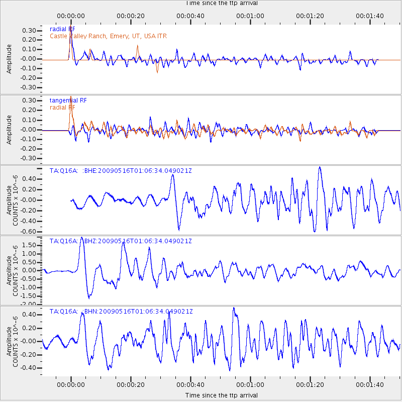
Signal To Noise
| Channel | StoN | STA | LTA |
| TA:Q16A: :BHZ:20090516T01:06:34.049021Z | 15.489239 | 9.670207E-7 | 6.243178E-8 |
| TA:Q16A: :BHN:20090516T01:06:34.049021Z | 3.78472 | 2.2429305E-7 | 5.9262785E-8 |
| TA:Q16A: :BHE:20090516T01:06:34.049021Z | 2.8945522 | 2.194512E-7 | 7.5815244E-8 |
| Arrivals |
| Ps | 7.0 SECOND |
| PpPs | 27 SECOND |
| PsPs/PpSs | 34 SECOND |


