You are here: Home > Network List > TA - USArray Transportable Network (new EarthScope stations) Stations List
> Station F20K Avaraart Lake, AK, USA > Earthquake Result Viewer
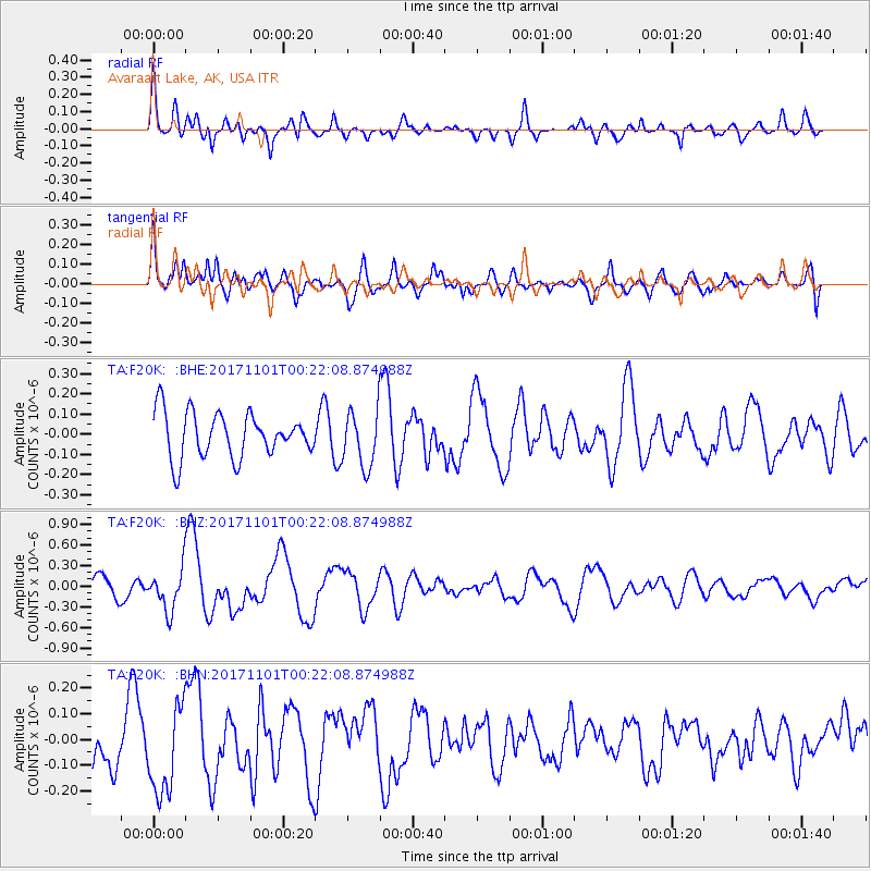
F20K Avaraart Lake, AK, USA - Earthquake Result Viewer
*The percent match for this event was below the threshold and hence no stack was calculated.
| Earthquake location: |
Loyalty Islands |
| Earthquake latitude/longitude: |
-21.7/168.9 |
| Earthquake time(UTC): |
2017/11/01 (305) 00:09:29 GMT |
| Earthquake Depth: |
10 km |
| Earthquake Magnitude: |
6.1 Mww |
| Earthquake Catalog/Contributor: |
NEIC PDE/us |
|
| Network: |
TA USArray Transportable Network (new EarthScope stations) |
| Station: |
F20K Avaraart Lake, AK, USA |
| Lat/Lon: |
67.05 N/155.73 W |
| Elevation: |
136 m |
|
| Distance: |
92.4 deg |
| Az: |
13.122 deg |
| Baz: |
212.565 deg |
| Ray Param: |
$rayparam |
*The percent match for this event was below the threshold and hence was not used in the summary stack. |
|
| Radial Match: |
57.018627 % |
| Radial Bump: |
400 |
| Transverse Match: |
58.695538 % |
| Transverse Bump: |
400 |
| SOD ConfigId: |
13570011 |
| Insert Time: |
2019-04-29 01:56:53.426 +0000 |
| GWidth: |
2.5 |
| Max Bumps: |
400 |
| Tol: |
0.001 |
|
Signal To Noise
| Channel | StoN | STA | LTA |
| TA:F20K: :BHZ:20171101T00:22:08.874988Z | 2.2747345 | 2.9892928E-7 | 1.3141282E-7 |
| TA:F20K: :BHN:20171101T00:22:08.874988Z | 1.3758123 | 1.7185015E-7 | 1.2490814E-7 |
| TA:F20K: :BHE:20171101T00:22:08.874988Z | 1.2606034 | 1.3945913E-7 | 1.10628875E-7 |
| Arrivals |
| Ps | |
| PpPs | |
| PsPs/PpSs | |


