You are here: Home > Network List > TA - USArray Transportable Network (new EarthScope stations) Stations List
> Station J18K Innoko River, AK, USA > Earthquake Result Viewer
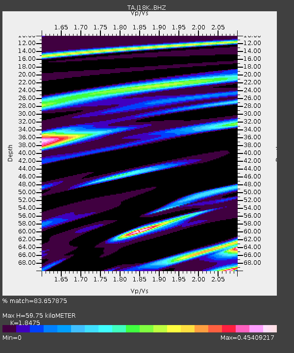
J18K Innoko River, AK, USA - Earthquake Result Viewer
| Earthquake location: |
Loyalty Islands |
| Earthquake latitude/longitude: |
-21.7/168.9 |
| Earthquake time(UTC): |
2017/11/01 (305) 00:09:29 GMT |
| Earthquake Depth: |
10 km |
| Earthquake Magnitude: |
6.1 Mww |
| Earthquake Catalog/Contributor: |
NEIC PDE/us |
|
| Network: |
TA USArray Transportable Network (new EarthScope stations) |
| Station: |
J18K Innoko River, AK, USA |
| Lat/Lon: |
63.47 N/156.72 W |
| Elevation: |
506 m |
|
| Distance: |
89.1 deg |
| Az: |
14.682 deg |
| Baz: |
211.646 deg |
| Ray Param: |
0.042104945 |
| Estimated Moho Depth: |
59.75 km |
| Estimated Crust Vp/Vs: |
1.85 |
| Assumed Crust Vp: |
6.182 km/s |
| Estimated Crust Vs: |
3.346 km/s |
| Estimated Crust Poisson's Ratio: |
0.29 |
|
| Radial Match: |
83.657875 % |
| Radial Bump: |
350 |
| Transverse Match: |
54.47843 % |
| Transverse Bump: |
400 |
| SOD ConfigId: |
13570011 |
| Insert Time: |
2019-04-29 01:57:16.889 +0000 |
| GWidth: |
2.5 |
| Max Bumps: |
400 |
| Tol: |
0.001 |
|

Signal To Noise
| Channel | StoN | STA | LTA |
| TA:J18K: :BHZ:20171101T00:21:53.749988Z | 2.993218 | 4.6282645E-7 | 1.5462504E-7 |
| TA:J18K: :BHN:20171101T00:21:53.749988Z | 0.9349945 | 1.3333363E-7 | 1.4260365E-7 |
| TA:J18K: :BHE:20171101T00:21:53.749988Z | 0.574709 | 1.0561742E-7 | 1.8377547E-7 |
| Arrivals |
| Ps | 8.3 SECOND |
| PpPs | 27 SECOND |
| PsPs/PpSs | 35 SECOND |


