You are here: Home > Network List > TA - USArray Transportable Network (new EarthScope stations) Stations List
> Station Q16A Castle Valley Ranch, Emery, UT, USA > Earthquake Result Viewer
Q16A Castle Valley Ranch, Emery, UT, USA - Earthquake Result Viewer
| Earthquake location: |
Tonga Islands |
| Earthquake latitude/longitude: |
-21.9/-173.8 |
| Earthquake time(UTC): |
2008/10/19 (293) 05:10:33 GMT |
| Earthquake Depth: |
29 km |
| Earthquake Magnitude: |
6.8 MB, 7.0 MS, 6.9 MW, 6.9 MW |
| Earthquake Catalog/Contributor: |
WHDF/NEIC |
|
| Network: |
TA USArray Transportable Network (new EarthScope stations) |
| Station: |
Q16A Castle Valley Ranch, Emery, UT, USA |
| Lat/Lon: |
38.92 N/111.17 W |
| Elevation: |
1912 m |
|
| Distance: |
84.2 deg |
| Az: |
44.145 deg |
| Baz: |
236.032 deg |
| Ray Param: |
0.045626868 |
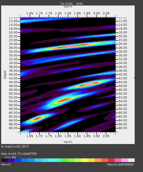
| Estimated Moho Depth: |
44.75 km |
| Estimated Crust Vp/Vs: |
1.96 |
| Assumed Crust Vp: |
6.207 km/s |
| Estimated Crust Vs: |
3.167 km/s |
| Estimated Crust Poisson's Ratio: |
0.32 |
|
| Radial Match: |
95.2972 % |
| Radial Bump: |
313 |
| Transverse Match: |
93.24474 % |
| Transverse Bump: |
381 |
| SOD ConfigId: |
2556 |
| Insert Time: |
2010-03-06 05:46:39.614 +0000 |
| GWidth: |
2.5 |
| Max Bumps: |
400 |
| Tol: |
0.001 |
|
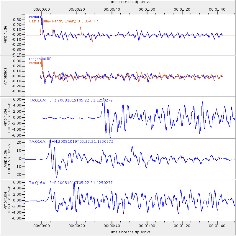
Signal To Noise
| Channel | StoN | STA | LTA |
| TA:Q16A: :BHN:20081019T05:22:31.125027Z | 86.40394 | 7.3255273E-6 | 8.478233E-8 |
| TA:Q16A: :BHE:20081019T05:22:31.125027Z | 11.893855 | 1.1740506E-6 | 9.8710686E-8 |
| TA:Q16A: :BHZ:20081019T05:22:31.125027Z | 12.295227 | 1.4275297E-6 | 1.1610438E-7 |
| Arrivals |
| Ps | 7.1 SECOND |
| PpPs | 21 SECOND |
| PsPs/PpSs | 28 SECOND |


