You are here: Home > Network List > TA - USArray Transportable Network (new EarthScope stations) Stations List
> Station R11B Troy Canyon, Currant, NV, USA > Earthquake Result Viewer
R11B Troy Canyon, Currant, NV, USA - Earthquake Result Viewer
| Earthquake location: |
Loyalty Islands |
| Earthquake latitude/longitude: |
-21.7/168.9 |
| Earthquake time(UTC): |
2017/11/01 (305) 00:09:29 GMT |
| Earthquake Depth: |
10 km |
| Earthquake Magnitude: |
6.1 Mww |
| Earthquake Catalog/Contributor: |
NEIC PDE/us |
|
| Network: |
TA USArray Transportable Network (new EarthScope stations) |
| Station: |
R11B Troy Canyon, Currant, NV, USA |
| Lat/Lon: |
38.35 N/115.59 W |
| Elevation: |
1767 m |
|
| Distance: |
92.5 deg |
| Az: |
49.631 deg |
| Baz: |
244.285 deg |
| Ray Param: |
0.041440398 |
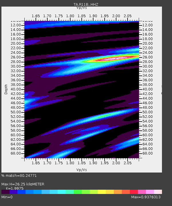
| Estimated Moho Depth: |
26.25 km |
| Estimated Crust Vp/Vs: |
2.00 |
| Assumed Crust Vp: |
6.276 km/s |
| Estimated Crust Vs: |
3.142 km/s |
| Estimated Crust Poisson's Ratio: |
0.33 |
|
| Radial Match: |
80.24771 % |
| Radial Bump: |
400 |
| Transverse Match: |
64.289215 % |
| Transverse Bump: |
400 |
| SOD ConfigId: |
13570011 |
| Insert Time: |
2019-04-29 01:58:01.961 +0000 |
| GWidth: |
2.5 |
| Max Bumps: |
400 |
| Tol: |
0.001 |
|

Signal To Noise
| Channel | StoN | STA | LTA |
| TA:R11B: :HHZ:20171101T00:22:09.650012Z | 3.335489 | 3.1059878E-7 | 9.311941E-8 |
| TA:R11B: :HHN:20171101T00:22:09.650012Z | 3.3108366 | 1.8983863E-7 | 5.7338568E-8 |
| TA:R11B: :HHE:20171101T00:22:09.650012Z | 1.0672566 | 5.5364545E-8 | 5.187557E-8 |
| Arrivals |
| Ps | 4.2 SECOND |
| PpPs | 12 SECOND |
| PsPs/PpSs | 17 SECOND |


