You are here: Home > Network List > TA - USArray Transportable Network (new EarthScope stations) Stations List
> Station R32K Eaglecrest, AK, USA > Earthquake Result Viewer
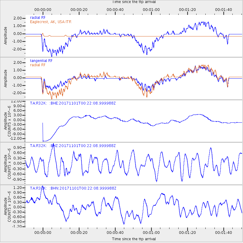
R32K Eaglecrest, AK, USA - Earthquake Result Viewer
*The percent match for this event was below the threshold and hence no stack was calculated.
| Earthquake location: |
Loyalty Islands |
| Earthquake latitude/longitude: |
-21.7/168.9 |
| Earthquake time(UTC): |
2017/11/01 (305) 00:09:29 GMT |
| Earthquake Depth: |
10 km |
| Earthquake Magnitude: |
6.1 Mww |
| Earthquake Catalog/Contributor: |
NEIC PDE/us |
|
| Network: |
TA USArray Transportable Network (new EarthScope stations) |
| Station: |
R32K Eaglecrest, AK, USA |
| Lat/Lon: |
58.27 N/134.52 W |
| Elevation: |
386 m |
|
| Distance: |
92.4 deg |
| Az: |
26.183 deg |
| Baz: |
230.934 deg |
| Ray Param: |
$rayparam |
*The percent match for this event was below the threshold and hence was not used in the summary stack. |
|
| Radial Match: |
39.497017 % |
| Radial Bump: |
400 |
| Transverse Match: |
36.30651 % |
| Transverse Bump: |
400 |
| SOD ConfigId: |
13570011 |
| Insert Time: |
2019-04-29 01:58:05.559 +0000 |
| GWidth: |
2.5 |
| Max Bumps: |
400 |
| Tol: |
0.001 |
|
Signal To Noise
| Channel | StoN | STA | LTA |
| TA:R32K: :BHZ:20171101T00:22:08.999988Z | 1.560179 | 4.517235E-7 | 2.8953315E-7 |
| TA:R32K: :BHN:20171101T00:22:08.999988Z | 2.0096867 | 1.3135358E-6 | 6.536023E-7 |
| TA:R32K: :BHE:20171101T00:22:08.999988Z | 0.9661673 | 5.6609706E-6 | 5.8592036E-6 |
| Arrivals |
| Ps | |
| PpPs | |
| PsPs/PpSs | |


