You are here: Home > Network List > TA - USArray Transportable Network (new EarthScope stations) Stations List
> Station Q16A Castle Valley Ranch, Emery, UT, USA > Earthquake Result Viewer
Q16A Castle Valley Ranch, Emery, UT, USA - Earthquake Result Viewer
| Earthquake location: |
Hokkaido, Japan Region |
| Earthquake latitude/longitude: |
41.9/143.8 |
| Earthquake time(UTC): |
2008/09/11 (255) 00:20:50 GMT |
| Earthquake Depth: |
25 km |
| Earthquake Magnitude: |
6.1 MB, 7.0 MS, 6.8 MW, 6.8 MW |
| Earthquake Catalog/Contributor: |
WHDF/NEIC |
|
| Network: |
TA USArray Transportable Network (new EarthScope stations) |
| Station: |
Q16A Castle Valley Ranch, Emery, UT, USA |
| Lat/Lon: |
38.92 N/111.17 W |
| Elevation: |
1912 m |
|
| Distance: |
74.6 deg |
| Az: |
51.364 deg |
| Baz: |
311.616 deg |
| Ray Param: |
0.052161135 |
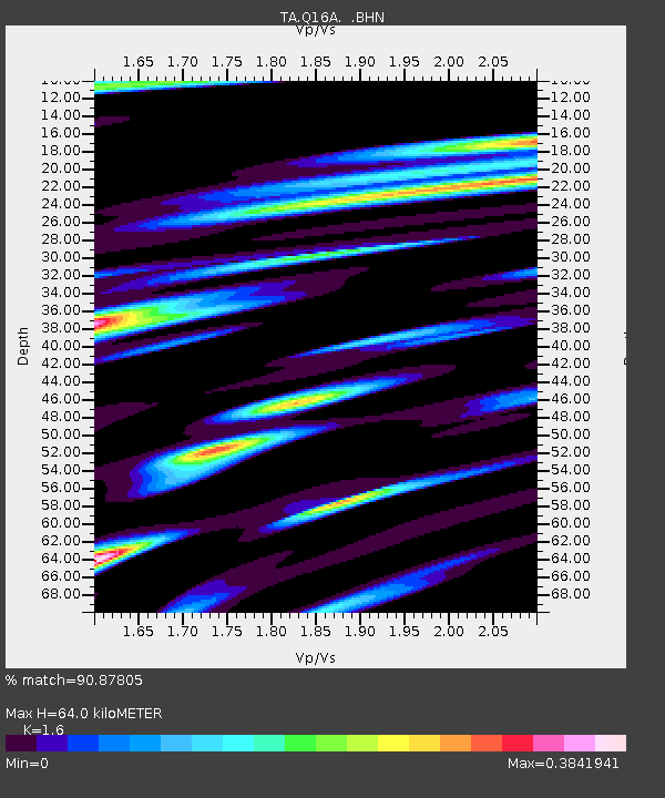
| Estimated Moho Depth: |
64.0 km |
| Estimated Crust Vp/Vs: |
1.60 |
| Assumed Crust Vp: |
6.207 km/s |
| Estimated Crust Vs: |
3.879 km/s |
| Estimated Crust Poisson's Ratio: |
0.18 |
|
| Radial Match: |
90.87805 % |
| Radial Bump: |
400 |
| Transverse Match: |
80.19792 % |
| Transverse Bump: |
400 |
| SOD ConfigId: |
2560 |
| Insert Time: |
2010-03-06 05:46:44.405 +0000 |
| GWidth: |
2.5 |
| Max Bumps: |
400 |
| Tol: |
0.001 |
|
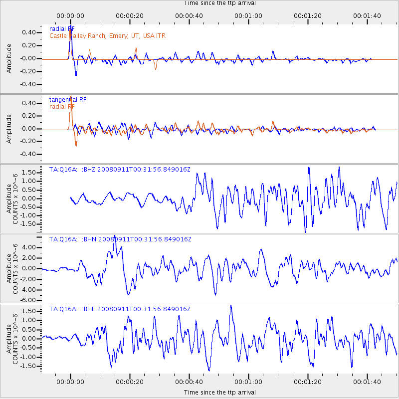
Signal To Noise
| Channel | StoN | STA | LTA |
| TA:Q16A: :BHN:20080911T00:31:56.849016Z | 2.886862 | 6.9726235E-7 | 2.415295E-7 |
| TA:Q16A: :BHE:20080911T00:31:56.849016Z | 0.8685137 | 1.9955377E-7 | 2.2976468E-7 |
| TA:Q16A: :BHZ:20080911T00:31:56.849016Z | 0.6008693 | 1.3143017E-7 | 2.1873338E-7 |
| Arrivals |
| Ps | 6.4 SECOND |
| PpPs | 26 SECOND |
| PsPs/PpSs | 32 SECOND |


