You are here: Home > Network List > TA - USArray Transportable Network (new EarthScope stations) Stations List
> Station Q16A Castle Valley Ranch, Emery, UT, USA > Earthquake Result Viewer
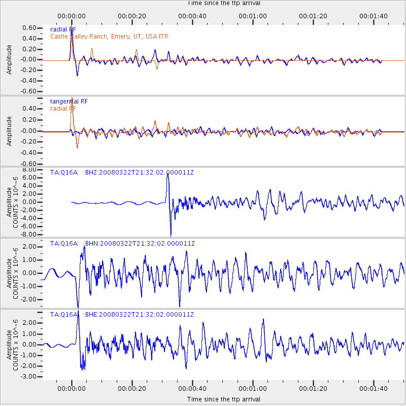
Q16A Castle Valley Ranch, Emery, UT, USA - Earthquake Result Viewer
| Earthquake location: |
Andreanof Islands, Aleutian Is. |
| Earthquake latitude/longitude: |
52.2/-178.7 |
| Earthquake time(UTC): |
2008/03/22 (082) 21:24:11 GMT |
| Earthquake Depth: |
132 km |
| Earthquake Magnitude: |
5.8 MB, 6.2 MW, 6.1 MW |
| Earthquake Catalog/Contributor: |
WHDF/NEIC |
|
| Network: |
TA USArray Transportable Network (new EarthScope stations) |
| Station: |
Q16A Castle Valley Ranch, Emery, UT, USA |
| Lat/Lon: |
38.92 N/111.17 W |
| Elevation: |
1912 m |
|
| Distance: |
47.4 deg |
| Az: |
78.209 deg |
| Baz: |
309.4 deg |
| Ray Param: |
0.06954191 |
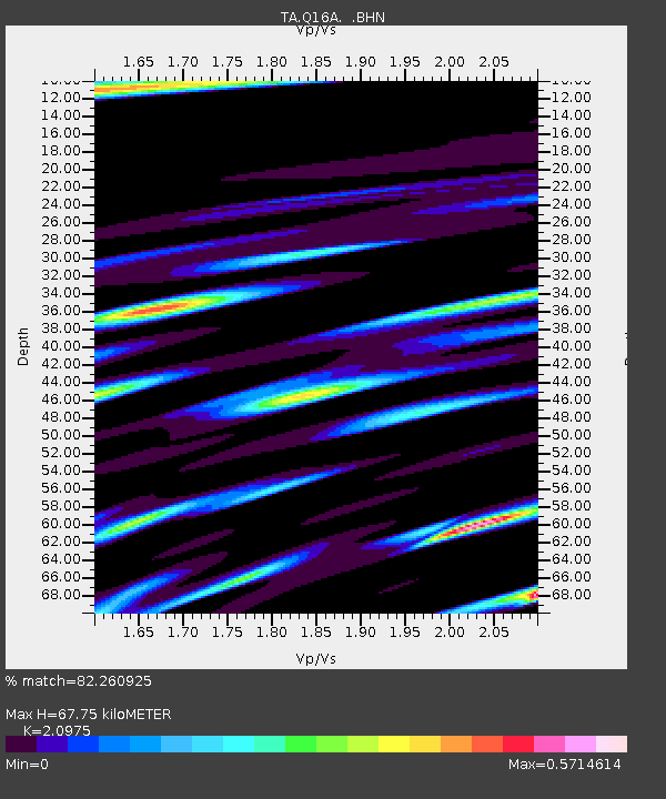
| Estimated Moho Depth: |
67.75 km |
| Estimated Crust Vp/Vs: |
2.10 |
| Assumed Crust Vp: |
6.207 km/s |
| Estimated Crust Vs: |
2.959 km/s |
| Estimated Crust Poisson's Ratio: |
0.35 |
|
| Radial Match: |
82.260925 % |
| Radial Bump: |
330 |
| Transverse Match: |
75.43911 % |
| Transverse Bump: |
400 |
| SOD ConfigId: |
2564 |
| Insert Time: |
2010-03-06 05:46:53.084 +0000 |
| GWidth: |
2.5 |
| Max Bumps: |
400 |
| Tol: |
0.001 |
|
Signal To Noise
| Channel | StoN | STA | LTA |
| TA:Q16A: :BHN:20080322T21:32:02.000011Z | 5.4816513 | 1.1915927E-6 | 2.1737841E-7 |
| TA:Q16A: :BHE:20080322T21:32:02.000011Z | 8.109407 | 1.3760813E-6 | 1.696895E-7 |
| TA:Q16A: :BHZ:20080322T21:32:02.000011Z | 15.949687 | 3.192166E-6 | 2.0013972E-7 |
| Arrivals |
| Ps | 13 SECOND |
| PpPs | 32 SECOND |
| PsPs/PpSs | 45 SECOND |


