You are here: Home > Network List > UW - Pacific Northwest Regional Seismic Network Stations List
> Station YACT Amboy, WA, USA > Earthquake Result Viewer
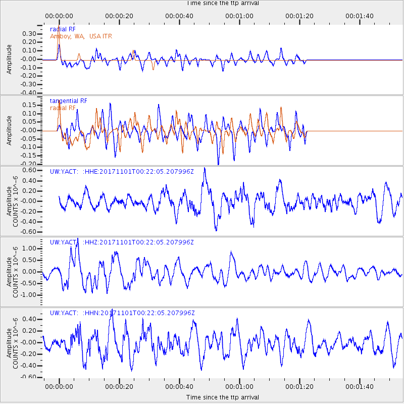
YACT Amboy, WA, USA - Earthquake Result Viewer
*The percent match for this event was below the threshold and hence no stack was calculated.
| Earthquake location: |
Loyalty Islands |
| Earthquake latitude/longitude: |
-21.7/168.9 |
| Earthquake time(UTC): |
2017/11/01 (305) 00:09:29 GMT |
| Earthquake Depth: |
10 km |
| Earthquake Magnitude: |
6.1 Mww |
| Earthquake Catalog/Contributor: |
NEIC PDE/us |
|
| Network: |
UW Pacific Northwest Regional Seismic Network |
| Station: |
YACT Amboy, WA, USA |
| Lat/Lon: |
45.93 N/122.42 W |
| Elevation: |
211 m |
|
| Distance: |
91.6 deg |
| Az: |
40.559 deg |
| Baz: |
240.028 deg |
| Ray Param: |
$rayparam |
*The percent match for this event was below the threshold and hence was not used in the summary stack. |
|
| Radial Match: |
54.934937 % |
| Radial Bump: |
372 |
| Transverse Match: |
60.239094 % |
| Transverse Bump: |
389 |
| SOD ConfigId: |
13570011 |
| Insert Time: |
2019-04-29 01:58:46.984 +0000 |
| GWidth: |
2.5 |
| Max Bumps: |
400 |
| Tol: |
0.001 |
|
Signal To Noise
| Channel | StoN | STA | LTA |
| UW:YACT: :HHZ:20171101T00:22:05.207996Z | 4.2392745 | 5.09617E-7 | 1.2021326E-7 |
| UW:YACT: :HHN:20171101T00:22:05.207996Z | 0.6747478 | 9.164021E-8 | 1.3581402E-7 |
| UW:YACT: :HHE:20171101T00:22:05.207996Z | 1.3766283 | 1.4200171E-7 | 1.0315181E-7 |
| Arrivals |
| Ps | |
| PpPs | |
| PsPs/PpSs | |


